Forecast Details for Guaynabo, 061

Recent Locations: Scobey, MT   Perry, ME   Guaynabo, 061  
Tonight: Showers likely, mainly after midnight. Mostly cloudy, with a low around 70. East northeast wind around 7 mph. Chance of precipitation is 60%.
Friday: Scattered showers. Partly sunny, with a high near 83. East northeast wind 9 to 14 mph. Chance of precipitation is 50%. New precipitation amounts between a quarter and half of an inch possible.
Friday Night: Showers likely, mainly after 3am. Mostly cloudy, with a low around 70. East wind around 7 mph. Chance of precipitation is 60%. New precipitation amounts between a quarter and half of an inch possible.
Saturday: Showers likely, with thunderstorms also possible after noon. Mostly cloudy, with a high near 84. East wind 8 to 14 mph. Chance of precipitation is 70%.
Saturday Night: Showers likely and possibly a thunderstorm. Mostly cloudy, with a low around 71. East wind around 8 mph. Chance of precipitation is 70%.
Sunday: Showers likely, mainly after noon. Mostly cloudy, with a high near 84. East southeast wind 9 to 14 mph. Chance of precipitation is 70%.
Sunday Night: Scattered showers. Partly cloudy, with a low around 71. East southeast wind 7 to 9 mph. Chance of precipitation is 30%.
Monday: Scattered showers, mainly before noon. Mostly sunny, with a high near 85. East southeast wind 9 to 15 mph. Chance of precipitation is 40%.
Monday Night: Scattered showers. Partly cloudy, with a low around 72. Southeast wind around 8 mph. Chance of precipitation is 30%.
Tuesday: Scattered showers, mainly after noon. Partly sunny, with a high near 86. Chance of precipitation is 50%.
Tuesday Night: Scattered showers. Partly cloudy, with a low around 73. Chance of precipitation is 30%.
Wednesday: Scattered showers. Mostly sunny, with a high near 87. Chance of precipitation is 30%.
Wednesday Night: Scattered showers. Partly cloudy, with a low around 72. Chance of precipitation is 30%.
Thursday: Scattered showers. Mostly sunny, with a high near 86. Chance of precipitation is 40%.

Want more detail? Get the Complete 7 Day and Night Detailed Forecast!


Weather Topic: What is Snow?

Home - Education - Precipitation - Snow

Snow Next Topic: Stratocumulus Clouds

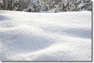
Snow is precipitation taking the form of ice crystals. Each ice crystal, or snowflake, has unique characteristics, but all of them grow in a hexagonal structure. Snowfall can last for sustained periods of time and result in significant buildup of snow on the ground.

On the earth's surface, snow starts out light and powdery, but as it begins to melt it tends to become more granular, producing small bits of ice which have the consistency of sand. After several cycles of melting and freezing, snow can become very dense and ice-like, commonly known as snow pack.

Next Topic: Stratocumulus Clouds

Weather Topic: What are Stratus Clouds?

Home - Education - Cloud Types - Stratus Clouds

Stratus Clouds Next Topic: Wall Clouds

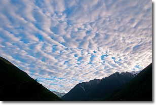
Stratus clouds are similar to altostratus clouds, but form at a lower altitude and are identified by their fog-like appearance, lacking the distinguishing features of most clouds.

Stratus clouds are wider than most clouds, and their base has a smooth, uniform look which is lighter in color than a nimbostratus cloud. The presence of a stratus cloud indicates the possibility of minor precipitation, such as drizzle, but heavier precipitation does not typically arrive in the form of a stratus cloud.

Next Topic: Wall Clouds

Current conditions powered by WeatherAPI.com