Weather Alerts for Arizona
1. Air Quality Alert for: Maricopa, AZ
2. Air Quality Alert for: Pinal, AZ
3. Extreme Heat Warning for: Aguila Valley; Tonopah Desert; Gila Bend; Cave Creek/New River; New River Mesa; Rio Verde/Salt River; Fountain Hills/East Mesa; Superior; Northwest Pinal County; West Pinal County; Apache Junction/Gold Canyon; Sonoran Desert Natl Monument
4. Extreme Heat Warning for: Northwest Plateau; Lake Havasu and Fort Mohave; Northwest Deserts; Lake Mead National Recreation Area; Owens Valley; Death Valley National Park; Western Mojave Desert; Eastern Mojave Desert, Including the Mojave National Preserve; Morongo Basin; Cadiz Basin; San Bernardino County-Upper Colorado River Valley; Lincoln County; Northeast Clark County; Western Clark and Southern Nye County; Las Vegas Valley; Lake Mead National Recreation Area; Southern Clark County
5. Extreme Heat Warning for: Northwest Valley; Buckeye/Avondale; Deer Valley; Central Phoenix; North Phoenix/Glendale; Scottsdale/Paradise Valley; East Valley; South Mountain/Ahwatukee; Southeast Valley/Queen Creek
6. Extreme Heat Warning for: Parker Valley; Kofa; Yuma; Central La Paz; Southeast Yuma County; Gila River Valley; Joshua Tree NP West; Joshua Tree NP East; Imperial County Southwest; Salton Sea; Chuckwalla Mountains; Imperial County Southeast; Imperial County West; Imperial Valley; Chiriaco Summit; Palo Verde Valley; Chuckwalla Valley
7. Extreme Heat Warning for: Tucson Metro Area including Tucson/Green Valley/Marana/Vail; South Central Pinal County including Eloy/Picacho Peak State Park; Southeast Pinal County including Kearny/Mammoth/Oracle
8. Flood Watch for: Kaibab Plateau; Marble and Glen Canyons; Grand Canyon Country
Want more detail? Get the Complete 7 Day and Night Detailed Forecast!
Current U.S. National Radar--Current
The Current National Weather Radar is shown below with a UTC Time (subtract 5 hours from UTC to get Eastern Time).

National Weather Forecast--Current
The Current National Weather Forecast and National Weather Map are shown below.

National Weather Forecast for Tomorrow
Tomorrow National Weather Forecast and Tomorrow National Weather Map are show below.

North America Water Vapor (Moisture)
This map shows recent moisture content over North America. Bright and colored areas show high moisture (ie, clouds); brown indicates very little moisture present; black indicates no moisture.

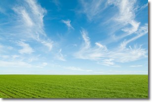
Weather Topic: What are Cirrus Clouds?
Home - Education - Cloud Types - Cirrus Clouds
 Next Topic: Condensation
Cirrus clouds are high-level clouds that occur above 20,000 feet
and are composed mainly of ice crystals.
They are thin and wispy in appearance.
What do they indicate?
They are often the first sign of an approaching storm.
Next Topic: Condensation
Weather Topic: What are Contrails?
Home - Education - Cloud Types - Contrails
 Next Topic: Cumulonimbus Clouds
A contrail is an artificial cloud, created by the passing of an
aircraft.
Contrails form because water vapor in the exhaust of aircraft engines is suspended
in the air under certain temperatures and humidity conditions. These contrails
are called exhaust contrails.
Another type of contrail can form due to a temporary reduction in air pressure
moving over the plane's surface, causing condensation.
These are called aerodynamic contrails.
When you can see your breath on a cold day, it is also because of condensation.
The reason contrails last longer than the condensation from your breath is
because the water in contrails freezes into ice particles.
Next Topic: Cumulonimbus Clouds
Current conditions powered by WeatherAPI.com


