Weather Alert in Texas
Flood Advisory issued September 5 at 2:51PM CDT until September 5 at 6:00PM CDT by NWS San Angelo TX
AREAS AFFECTED: Tom Green, TX
DESCRIPTION: * WHAT...Urban and small stream flooding caused by excessive rainfall is expected. * WHERE...A portion of west central Texas, including the following county, Tom Green. * WHEN...Until 600 PM CDT. * IMPACTS...Minor flooding in low-lying and poor drainage areas. * ADDITIONAL DETAILS... - At 248 PM CDT, Doppler radar indicated heavy rain due to thunderstorms. There has been a report of minor street flooding in San Angelo. This will cause urban and small stream flooding. Around 1 inch has fallen and additional rainfall is expected. - Some locations that will experience flooding include... San Angelo, Lake Nasworthy, Goodfellow Air Force Base, O.C. Fisher Reservoir and San Angelo State Park. - This includes the following Low Water Crossings... College Hills and Millbrook, Southwest Blvd and Loop 306, Howard and Webster, Jackson From Knickerbocker to South Bryant, Parkwood and Lindenwood, 1500 Block of Spaulding, Sul Ross At Red Arroyo Crossing, Huntington and Sunset, Huntington and Sunset and 300 block of North Archer. - http://www.weather.gov/safety/flood
INSTRUCTION: Turn around, don't drown when encountering flooded roads. Most flood deaths occur in vehicles.
Want more detail? Get the Complete 7 Day and Night Detailed Forecast!
Current U.S. National Radar--Current
The Current National Weather Radar is shown below with a UTC Time (subtract 5 hours from UTC to get Eastern Time).

National Weather Forecast--Current
The Current National Weather Forecast and National Weather Map are shown below.

National Weather Forecast for Tomorrow
Tomorrow National Weather Forecast and Tomorrow National Weather Map are show below.

North America Water Vapor (Moisture)
This map shows recent moisture content over North America. Bright and colored areas show high moisture (ie, clouds); brown indicates very little moisture present; black indicates no moisture.

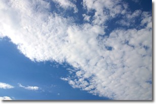
Weather Topic: What are Altocumulus Clouds?
Home - Education - Cloud Types - Altocumulus Clouds
 Next Topic: Altostratus Clouds
Similar to cirrocumulus clouds, altocumulus clouds are
characterized by cloud patches. They are distinguished by larger cloudlets
than cirrocumulus clouds but are still smaller than stratocumulus clouds.
Altocumulus clouds most commonly form in middle altitudes (between 2 and 5 km)
and may resemble, at times, the shape of a flying saucer.
These uncommon formations, called altocumulus lenticularis, are created by uplift
in the atmosphere and are most often seen in close proximity to mountains.
Next Topic: Altostratus Clouds
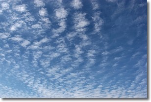
Weather Topic: What are Cirrocumulus Clouds?
Home - Education - Cloud Types - Cirrocumulus Clouds
 Next Topic: Cirrostratus Clouds
Cirrocumulus clouds form at high altitudes (usually around 5 km)
and have distinguishing characteristics displayed in a fine layer of
small cloud patches. These small cloud patches are sometimes referred to as
"cloudlets" in relation to the whole cloud formation.
Cirrocumulus clouds are formed from ice crystals and water droplets. Often, the
water droplets in the cloud freeze into ice crystals and the cloud becomes a
cirrostratus cloud. Because of this common occurrence, cirrocumulus cloud
formations generally pass rapidly.
Next Topic: Cirrostratus Clouds
Current conditions powered by WeatherAPI.com


