Weather Alert in Texas
Severe Thunderstorm Warning issued September 5 at 7:20PM CDT until September 5 at 8:00PM CDT by NWS Fort Worth TX
AREAS AFFECTED: Grayson, TX
DESCRIPTION: SVRFWD The National Weather Service in Fort Worth has issued a * Severe Thunderstorm Warning for... Southern Grayson County in north central Texas... * Until 800 PM CDT. * At 720 PM CDT, a severe thunderstorm was located over Gunter, or 14 miles southwest of Sherman, moving northeast at 35 mph. HAZARD...65 mph wind gusts and quarter size hail. SOURCE...Radar indicated. IMPACT...Hail damage to vehicles is expected. Expect wind damage to roofs, siding, and trees. * This severe thunderstorm will be near... Howe, Gunter, and Dorchester around 725 PM CDT. Sherman and Van Alstyne around 730 PM CDT. Bells around 750 PM CDT. Other locations impacted by this severe thunderstorm include Boddie, Luella, Southmayd, Ida, White Mound, Ambrose, Farmington, Elmont, and Lake Ray Roberts.
INSTRUCTION: For your protection get inside a sturdy structure and stay away from windows.
Want more detail? Get the Complete 7 Day and Night Detailed Forecast!
Current U.S. National Radar--Current
The Current National Weather Radar is shown below with a UTC Time (subtract 5 hours from UTC to get Eastern Time).

National Weather Forecast--Current
The Current National Weather Forecast and National Weather Map are shown below.

National Weather Forecast for Tomorrow
Tomorrow National Weather Forecast and Tomorrow National Weather Map are show below.

North America Water Vapor (Moisture)
This map shows recent moisture content over North America. Bright and colored areas show high moisture (ie, clouds); brown indicates very little moisture present; black indicates no moisture.

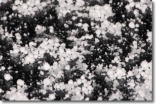
Weather Topic: What is Graupel?
Home - Education - Precipitation - Graupel
 Next Topic: Hail
Graupel is a form of precipitation that is created by atmospheric conditions
which cause supercooled water droplets to contact snow crystals and freeze to
their surface.
Sometimes known as soft hail or snow pellets, graupel is delicate and easily
destroyed by touch. Whereas hail usually falls during severe weather, graupel
doesn't require such conditions to form, and can form in mild precipitation
similar to situations which produce snowfall.
Next Topic: Hail
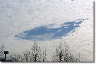
Weather Topic: What are Hole Punch Clouds?
Home - Education - Cloud Types - Hole Punch Clouds
 Next Topic: Mammatus Clouds
A hole punch cloud is an unusual occurrence when a disk-shaped
hole appears in a cirrostratus, cirrocumulus, or altocumulus cloud.
When part of the cloud forms ice crystals, water droplets in the surrounding area
of the cloud evaporate. The effect of this process produces a large elliptical
gap in the cloud. The hole punch cloud formation is rare, but it is not specific
to any geographic area.
Other names which have been used to describe this phenomena include fallstreak hole,
skypunch, and cloud hole.
Next Topic: Mammatus Clouds
Current conditions powered by WeatherAPI.com


