Weather Alert in Wisconsin
Flood Warning issued April 4 at 4:49AM CDT until April 5 at 1:00AM CDT by NWS Milwaukee/Sullivan WI
AREAS AFFECTED: Racine, WI
DESCRIPTION: ...The Flood Warning continues for the following rivers in Wisconsin...Illinois... Root River Canal At Raymond affecting Racine County. Fox River Lower Near New Munster affecting Lake and Kenosha Counties. * WHAT...Minor flooding is occurring and minor flooding is forecast. * WHERE...Root River Canal at Raymond. * WHEN...Until just after midnight tonight. * IMPACTS...At 11.0 feet, Floodwaters are in the back yards of a few homes in the Village of Raymond. Water floods Koerber Park on 6 Mile Road. There is widespread flooding of lowland and agricultural land. * ADDITIONAL DETAILS... - At 4:00 AM CDT Saturday the stage was 10.1 feet. - Bankfull stage is 7.0 feet. - Recent Activity...The maximum river stage in the 24 hours ending at 4:00 AM CDT Saturday was 10.1 feet. - Forecast...The river is expected to fall below flood stage this afternoon and continue falling to 3.4 feet Friday evening. - Flood stage is 9.0 feet. - Flood History...This crest compares to a previous crest of 10.1 feet on 03/13/2006. - http://www.weather.gov/safety/flood
INSTRUCTION: Motorists should not attempt to drive around barricades or drive cars through flooded areas. Additional information is available at www.weather.gov. The next statement will be issued this afternoon at 500 PM CDT.
Want more detail? Get the Complete 7 Day and Night Detailed Forecast!
Current U.S. National Radar--Current
The Current National Weather Radar is shown below with a UTC Time (subtract 5 hours from UTC to get Eastern Time).

National Weather Forecast--Current
The Current National Weather Forecast and National Weather Map are shown below.

National Weather Forecast for Tomorrow
Tomorrow National Weather Forecast and Tomorrow National Weather Map are show below.

North America Water Vapor (Moisture)
This map shows recent moisture content over North America. Bright and colored areas show high moisture (ie, clouds); brown indicates very little moisture present; black indicates no moisture.

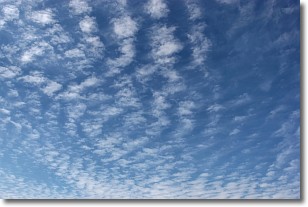
Weather Topic: What are Cirrocumulus Clouds?
Home - Education - Cloud Types - Cirrocumulus Clouds
 Next Topic: Cirrostratus Clouds
Cirrocumulus clouds form at high altitudes (usually around 5 km)
and have distinguishing characteristics displayed in a fine layer of
small cloud patches. These small cloud patches are sometimes referred to as
"cloudlets" in relation to the whole cloud formation.
Cirrocumulus clouds are formed from ice crystals and water droplets. Often, the
water droplets in the cloud freeze into ice crystals and the cloud becomes a
cirrostratus cloud. Because of this common occurrence, cirrocumulus cloud
formations generally pass rapidly.
Next Topic: Cirrostratus Clouds
Weather Topic: What are Cirrus Clouds?
Home - Education - Cloud Types - Cirrus Clouds
 Next Topic: Condensation
Cirrus clouds are high-level clouds that occur above 20,000 feet
and are composed mainly of ice crystals.
They are thin and wispy in appearance.
What do they indicate?
They are often the first sign of an approaching storm.
Next Topic: Condensation
Current conditions powered by WeatherAPI.com


