Weather Alert in Idaho
Flood Watch issued August 26 at 1:23PM MDT until August 28 at 12:00AM MDT by NWS Pocatello ID
AREAS AFFECTED: Shoshone/Lava Beds; Arco/Mud Lake Desert; Upper Snake River Plain; Lower Snake River Plain; Eastern Magic Valley; Southern Hills/Albion Mountains; Raft River Region; Marsh and Arbon Highlands; Franklin/Eastern Oneida Region; Bear River Range; Bear Lake Valley; Blackfoot Mountains; Caribou Range; Big Hole Mountains; Teton Valley; Centennial Mountains/Island Park; Beaverhead/Lemhi Highlands; Lost River Valleys; Lost River Range; Challis/Pahsimeroi Valleys; Frank Church Wilderness; Sun Valley Region; Big Lost Highlands/Copper Basin; Wood River Foothills
DESCRIPTION: A surge of deep monsoonal moisture will bring a prolonged period of rainfall across eastern Idaho which will result in widespread rainfall totals around 1 inch with locally higher amounts closer to 2 inches possible. This could result in areas of flooding within urban areas along with small creeks and streams. Additionally, there will be some potential for flash flooding, especially over recent burn scars. * WHAT...Flooding caused by excessive rainfall is possible. Flash flooding caused by excessive rainfall is also possible over area burn scars. * WHERE...Portions of central, eastern, south central, and southeast Idaho, including the following areas, in central Idaho, Big Lost Highlands/Copper Basin, Challis/Pahsimeroi Valleys, Frank Church Wilderness, Lost River Range, Lost River Valley, Sun Valley Region and Wood River Foothills. In eastern Idaho, Beaverhead - Lemhi Highlands, Big Hole Mountains, Centennial Mountains - Island Park and Teton Valley. In south central Idaho, Eastern Magic Valley and Shoshone/Lava Beds. In southeast Idaho, Arco/Mud Lake Desert, Bear Lake Valley, Bear River Range, Blackfoot Mountains, Caribou Range, Franklin/Eastern Oneida Region, Lower Snake River Plain, Marsh and Arbon Highlands, Raft River Region, Southern Hills/Albion Mountains and Upper Snake River Plain. * WHEN...Through Wednesday evening. * IMPACTS...Excessive runoff may result in flooding of rivers, creeks, streams, and other low-lying and flood-prone locations. Creeks and streams may rise out of their banks. In addition, flooding may occur in poor drainage and urban areas. * ADDITIONAL DETAILS... - http://www.weather.gov/safety/flood
INSTRUCTION: You should monitor later forecasts and be alert for possible Flood Warnings. Those living in areas prone to flooding should be prepared to take action should flooding develop.
Want more detail? Get the Complete 7 Day and Night Detailed Forecast!
Current U.S. National Radar--Current
The Current National Weather Radar is shown below with a UTC Time (subtract 5 hours from UTC to get Eastern Time).

National Weather Forecast--Current
The Current National Weather Forecast and National Weather Map are shown below.

National Weather Forecast for Tomorrow
Tomorrow National Weather Forecast and Tomorrow National Weather Map are show below.

North America Water Vapor (Moisture)
This map shows recent moisture content over North America. Bright and colored areas show high moisture (ie, clouds); brown indicates very little moisture present; black indicates no moisture.

Weather Topic: What is Hail?
Home - Education - Precipitation - Hail
 Next Topic: Hole Punch Clouds
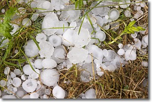
Hail is a form of precipitation which is recognized by large solid balls or
clumps of ice. Hail is created by thunderstorm clouds with strong updrafts of wind.
As the hailstones remain in the updraft, ice is deposited onto them until their
weight becomes heavy enough for them to fall to the earth's surface.
Hail storms can cause significant damage to crops, aircrafts, and man-made structures,
despite the fact that the duration is usually less than ten minutes.
Next Topic: Hole Punch Clouds
Weather Topic: What are Mammatus Clouds?
Home - Education - Cloud Types - Mammatus Clouds
 Next Topic: Nimbostratus Clouds
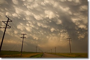
A mammatus cloud is a cloud with a unique feature which resembles
a web of pouches hanging along the base of the cloud.
In the United States, mammatus clouds tend to form in the warmer months, commonly
in the Midwest and eastern regions.
While they usually form at the bottom of a cumulonimbis cloud, they can also form
under altostratus, altocumulus, stratocumulus, and cirrus clouds. Mammatus clouds
warn that severe weather is close.
Next Topic: Nimbostratus Clouds
Current conditions powered by WeatherAPI.com


