Weather Alert in Iowa
Flood Watch issued August 23 at 9:19AM CDT until August 27 at 3:00PM CDT by NWS Quad Cities IA IL
AREAS AFFECTED: Muscatine; Louisa
DESCRIPTION: ...The Flood Watch is extended for the following rivers in Iowa... Cedar River near Conesville affecting Louisa and Muscatine Counties. * WHAT...Flooding is possible. * WHERE...Cedar River near Conesville. * WHEN...From Monday morning to Wednesday afternoon. * IMPACTS...At 13.5 feet, Water affects yards and access roads of residences along Iowa Highway 22. Water affects the lowest sections of campgrounds just north of I-80 along the river and the lowest sections of Jack Shuger Memorial Park in Moscow. Water is also on 152nd Street north of County Road F70. * ADDITIONAL DETAILS... - At 9:00 AM CDT Saturday the stage was 11.4 feet. - Forecast...Flood stage may be reached Monday morning. - Flood stage is 13.0 feet.
INSTRUCTION: If you are in the watch area, remain alert to possible flooding. Stay tuned to further developments by listening to your local radio, television, or NOAA Weather Radio for further information. The next statement will be issued by Sunday morning at 930 AM CDT.
Want more detail? Get the Complete 7 Day and Night Detailed Forecast!
Current U.S. National Radar--Current
The Current National Weather Radar is shown below with a UTC Time (subtract 5 hours from UTC to get Eastern Time).

National Weather Forecast--Current
The Current National Weather Forecast and National Weather Map are shown below.

National Weather Forecast for Tomorrow
Tomorrow National Weather Forecast and Tomorrow National Weather Map are show below.

North America Water Vapor (Moisture)
This map shows recent moisture content over North America. Bright and colored areas show high moisture (ie, clouds); brown indicates very little moisture present; black indicates no moisture.

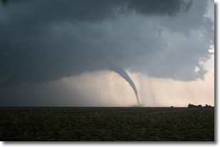
Weather Topic: What are Wall Clouds?
Home - Education - Cloud Types - Wall Clouds
 Next Topic: Altocumulus Clouds
A wall cloud forms underneath the base of a cumulonimbus cloud,
and can be a hotbed for deadly tornadoes.
Wall clouds are formed by air flowing into the cumulonimbus clouds, which can
result in the wall cloud descending from the base of the cumulonimbus cloud, or
rising fractus clouds which join to the base of the storm cloud as the wall cloud
takes shape.
Wall clouds can be very large, and in the Northern Hemisphere they generally
form at the southern edge of cumulonimbus clouds.
Next Topic: Altocumulus Clouds
Weather Topic: What are Altostratus Clouds?
Home - Education - Cloud Types - Altostratus Clouds
 Next Topic: Cirrocumulus Clouds
Altostratus clouds form at mid to high-level altitudes
(between 2 and 7 km) and are created by a warm, stable air mass which causes
water vapor
to condense as it rise through the atmosphere. Usually altostratus clouds are
featureless sheets characterized by a uniform color.
In some cases, wind punching through the cloud formation may give it a waved
appearance, called altostratus undulatus. Altostratus clouds
are commonly seen with other cloud formations accompanying them.
Next Topic: Cirrocumulus Clouds
Current conditions powered by WeatherAPI.com


