Weather Alert in Maine
Winter Weather Advisory issued April 2 at 2:41PM EDT until April 3 at 10:00AM EDT by NWS Gray ME
AREAS AFFECTED: Southern Oxford; Southern Franklin; Southern Somerset; Androscoggin; Kennebec; Interior Waldo; Interior Cumberland Highlands
DESCRIPTION: A light wintry mix will overspread the area late this evening. The wintry mix will transition to light freezing rain late tonight into early Friday morning. * WHAT...Mixed precipitation expected. Total snow accumulations of less than one inch, sleet accumulations up to one tenth of an inch, and ice accumulations around one tenth of an inch. * WHERE...Portions of south central, southwest, and western Maine. * WHEN...From 11 PM this evening to 10 AM EDT Friday. * IMPACTS...A period of mixed precipitation is expected with air temperatures remaining below freezing. Expect slippery road conditions and avoid travel if possible. Difficult travel conditions are possible due to icy road conditions. The hazardous conditions could impact the Friday morning commute.
INSTRUCTION: Slow down and use caution while traveling. Prepare for possible power outages. The latest road conditions can be obtained by going to newengland511.org
Want more detail? Get the Complete 7 Day and Night Detailed Forecast!
Current U.S. National Radar--Current
The Current National Weather Radar is shown below with a UTC Time (subtract 5 hours from UTC to get Eastern Time).

National Weather Forecast--Current
The Current National Weather Forecast and National Weather Map are shown below.

National Weather Forecast for Tomorrow
Tomorrow National Weather Forecast and Tomorrow National Weather Map are show below.

North America Water Vapor (Moisture)
This map shows recent moisture content over North America. Bright and colored areas show high moisture (ie, clouds); brown indicates very little moisture present; black indicates no moisture.

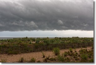
Weather Topic: What are Shelf Clouds?
Home - Education - Cloud Types - Shelf Clouds
 Next Topic: Sleet
A shelf cloud is similar to a wall cloud, but forms at the front
of a storm cloud, instead of at the rear, where wall clouds form.
A shelf cloud is caused by a series of events set into motion by the advancing
storm; first, cool air settles along the ground where precipitation has just fallen.
As the cool air is brought in, the warmer air is displaced, and rises above it,
because it is less dense. When the warmer air reaches the bottom of the storm cloud,
it begins to cool again, and the resulting condensation is a visible shelf cloud.
Next Topic: Sleet
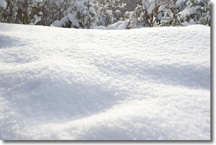
Weather Topic: What is Snow?
Home - Education - Precipitation - Snow
 Next Topic: Stratocumulus Clouds
Snow is precipitation taking the form of ice crystals. Each ice crystal, or snowflake,
has unique characteristics, but all of them grow in a hexagonal structure.
Snowfall can last for sustained periods of time and result in significant buildup
of snow on the ground.
On the earth's surface, snow starts out light and powdery, but as it begins to melt
it tends to become more granular, producing small bits of ice which have the consistency of
sand. After several cycles of melting and freezing, snow can become very dense
and ice-like, commonly known as snow pack.
Next Topic: Stratocumulus Clouds
Current conditions powered by WeatherAPI.com


