Weather Alert in Wisconsin
Winter Weather Advisory issued April 3 at 2:38AM CDT until April 4 at 7:00AM CDT by NWS La Crosse WI
AREAS AFFECTED: Taylor; Clark
DESCRIPTION: ...FREEZING RAIN IMPACTING NORTH CENTRAL WISCONSIN THIS EVENING INTO THE OVERNIGHT... .Freezing rain develops this evening and continues through the overnight for north central Wisconsin. This impacts Taylor County and northeast Clark County. The greatest ice accumulations are in eastern Taylor County. There is a tight gradient in ice accumulations owing to where the freezing line sets up, so additional shifts in the southward extent of the ice may be needed later in the day. * WHAT...Freezing rain expected. Total ice accumulations ranging from a glaze to a tenth of an inch of ice for northeast Clark and western and central Taylor County. Higher amounts between a tenth to three tenths for eastern Taylor County. * WHERE...Clark and Taylor Counties. * WHEN...From 9 PM this evening to 7 AM CDT Saturday. * IMPACTS...Power outages and tree damage are possible due to the ice. Slippery roads are possible.
INSTRUCTION: Slow down and use caution while traveling. Prepare for possible power outages. Visit 511wi.gov for road conditions.
Want more detail? Get the Complete 7 Day and Night Detailed Forecast!
Current U.S. National Radar--Current
The Current National Weather Radar is shown below with a UTC Time (subtract 5 hours from UTC to get Eastern Time).

National Weather Forecast--Current
The Current National Weather Forecast and National Weather Map are shown below.

National Weather Forecast for Tomorrow
Tomorrow National Weather Forecast and Tomorrow National Weather Map are show below.

North America Water Vapor (Moisture)
This map shows recent moisture content over North America. Bright and colored areas show high moisture (ie, clouds); brown indicates very little moisture present; black indicates no moisture.

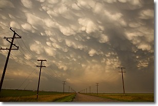
Weather Topic: What are Mammatus Clouds?
Home - Education - Cloud Types - Mammatus Clouds
 Next Topic: Nimbostratus Clouds
A mammatus cloud is a cloud with a unique feature which resembles
a web of pouches hanging along the base of the cloud.
In the United States, mammatus clouds tend to form in the warmer months, commonly
in the Midwest and eastern regions.
While they usually form at the bottom of a cumulonimbis cloud, they can also form
under altostratus, altocumulus, stratocumulus, and cirrus clouds. Mammatus clouds
warn that severe weather is close.
Next Topic: Nimbostratus Clouds
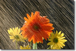
Weather Topic: What is Precipitation?
Home - Education - Precipitation - Precipitation
 Next Topic: Rain
Precipitation can refer to many different forms of water that
may fall from clouds. Precipitation occurs after a cloud has become saturated to
the point where its water particles are more dense than the air below the cloud.
In most cases, precipitation will reach the ground, but it is not uncommon for
precipitation to evaporate before it reaches the earth's surface.
When precipitation evaporates before it contacts the ground it is called Virga.
Graupel, hail, sleet, rain, drizzle, and snow are forms of precipitation, but fog
and mist are not considered precipitation because the water vapor which
constitutes them isn't dense enough to fall to the ground.
Next Topic: Rain
Current conditions powered by WeatherAPI.com


