Weather Alert in Wisconsin
Winter Weather Advisory issued April 3 at 2:38AM CDT until April 4 at 7:00AM CDT by NWS La Crosse WI
AREAS AFFECTED: Taylor; Clark
DESCRIPTION: ...FREEZING RAIN IMPACTING NORTH CENTRAL WISCONSIN THIS EVENING INTO THE OVERNIGHT... .Freezing rain develops this evening and continues through the overnight for north central Wisconsin. This impacts Taylor County and northeast Clark County. The greatest ice accumulations are in eastern Taylor County. There is a tight gradient in ice accumulations owing to where the freezing line sets up, so additional shifts in the southward extent of the ice may be needed later in the day. * WHAT...Freezing rain expected. Total ice accumulations ranging from a glaze to a tenth of an inch of ice for northeast Clark and western and central Taylor County. Higher amounts between a tenth to three tenths for eastern Taylor County. * WHERE...Clark and Taylor Counties. * WHEN...From 9 PM this evening to 7 AM CDT Saturday. * IMPACTS...Power outages and tree damage are possible due to the ice. Slippery roads are possible.
INSTRUCTION: Slow down and use caution while traveling. Prepare for possible power outages. Visit 511wi.gov for road conditions.
Want more detail? Get the Complete 7 Day and Night Detailed Forecast!
Current U.S. National Radar--Current
The Current National Weather Radar is shown below with a UTC Time (subtract 5 hours from UTC to get Eastern Time).

National Weather Forecast--Current
The Current National Weather Forecast and National Weather Map are shown below.

National Weather Forecast for Tomorrow
Tomorrow National Weather Forecast and Tomorrow National Weather Map are show below.

North America Water Vapor (Moisture)
This map shows recent moisture content over North America. Bright and colored areas show high moisture (ie, clouds); brown indicates very little moisture present; black indicates no moisture.

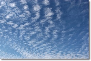
Weather Topic: What are Cirrocumulus Clouds?
Home - Education - Cloud Types - Cirrocumulus Clouds
 Next Topic: Cirrostratus Clouds
Cirrocumulus clouds form at high altitudes (usually around 5 km)
and have distinguishing characteristics displayed in a fine layer of
small cloud patches. These small cloud patches are sometimes referred to as
"cloudlets" in relation to the whole cloud formation.
Cirrocumulus clouds are formed from ice crystals and water droplets. Often, the
water droplets in the cloud freeze into ice crystals and the cloud becomes a
cirrostratus cloud. Because of this common occurrence, cirrocumulus cloud
formations generally pass rapidly.
Next Topic: Cirrostratus Clouds
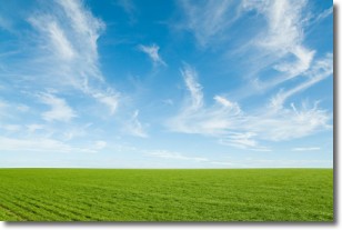
Weather Topic: What are Cirrus Clouds?
Home - Education - Cloud Types - Cirrus Clouds
 Next Topic: Condensation
Cirrus clouds are high-level clouds that occur above 20,000 feet
and are composed mainly of ice crystals.
They are thin and wispy in appearance.
What do they indicate?
They are often the first sign of an approaching storm.
Next Topic: Condensation
Current conditions powered by WeatherAPI.com


