Weather Alert in Kansas
Flood Warning issued August 27 at 2:06PM CDT until August 30 at 4:43AM CDT by NWS Wichita KS
AREAS AFFECTED: Butler, KS
DESCRIPTION: ...The National Weather Service in Wichita KS has issued a Flood Warning for the following rivers in Kansas... Whitewater River at Towanda affecting Butler County. Whitewater River at Augusta affecting Cowley and Butler Counties. * WHAT...Moderate flooding is forecast. * WHERE...Whitewater River at Towanda. * WHEN...From Thursday afternoon to early Saturday morning. * IMPACTS...At 25.0 feet, Flooding over cropland becomes more widespread. County roads flood at Southwest 40th Street on low spots near the river about 2 miles downstream of gage and along Southwest 60th Street just west of Fulton Road near the river located 4 miles south of Towanda. Further downstream, 5 miles south of Towanda, expect flooding across Southwest 70th Street near the river. * ADDITIONAL DETAILS... - At 1:30 PM CDT Wednesday the stage was 1.9 feet. - Forecast...The river is expected to rise above flood stage early tomorrow afternoon to a crest of 26.2 feet early Friday morning. It will then fall below flood stage Friday afternoon. - Flood stage is 22.0 feet.
INSTRUCTION: Do not drive into flooded areas or go around barricades. Nearly two feet of water will carry most vehicles away. Turn around, don't drown. Additional information is available at www.weather.gov. The next statement will be issued late tonight at 215 AM CDT.
Want more detail? Get the Complete 7 Day and Night Detailed Forecast!
Current U.S. National Radar--Current
The Current National Weather Radar is shown below with a UTC Time (subtract 5 hours from UTC to get Eastern Time).

National Weather Forecast--Current
The Current National Weather Forecast and National Weather Map are shown below.

National Weather Forecast for Tomorrow
Tomorrow National Weather Forecast and Tomorrow National Weather Map are show below.

North America Water Vapor (Moisture)
This map shows recent moisture content over North America. Bright and colored areas show high moisture (ie, clouds); brown indicates very little moisture present; black indicates no moisture.

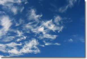
Weather Topic: What are Cirrostratus Clouds?
Home - Education - Cloud Types - Cirrostratus Clouds
 Next Topic: Cirrus Clouds
Cirrostratus clouds are high, thin clouds that form above
20,000 feet and are made mostly of ice crystals. They sometimes look like giant
feathers, horse tails, or curls of hair in the sky.
These clouds are pushed by the jet stream and can move at high speeds reaching
100 mph.
What do they indicate?
They indicate that a precipitation is likely within 24 hours.
Next Topic: Cirrus Clouds
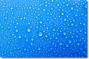
Weather Topic: What is Condensation?
Home - Education - Precipitation - Condensation
 Next Topic: Contrails
Condensation is the process which creates clouds, and therefore
it is a crucial process in the water cycle.
Condensation is the change of matter from a state of gas into a state of liquid,
and it happens because water molecules release heat into the atmosphere and
become organized into a more closely packed structure, what we might see as
water droplets.
Water is always present in the air around us as a vapor, but it's too small for
us to see. When water undergoes the process of condensation it becomes organized
into visible water droplets. You've probably seen condensation happen before on the
surface of a cold drink!
Next Topic: Contrails
Current conditions powered by WeatherAPI.com


