Weather Alert in Michigan
Flood Watch issued April 2 at 12:50PM EDT until April 6 at 2:00PM EDT by NWS Grand Rapids MI
AREAS AFFECTED: Newaygo
DESCRIPTION: ...The National Weather Service in Grand Rapids MI has issued a Flood Watch for the following rivers in Michigan... Muskegon River at Newaygo affecting Newaygo County. Muskegon River at Bridgeton affecting Newaygo County. .1 To 2 inches of rain has fallen in recent days, with an additional 1 to 2 inches expected over the next few days. The Muskegon River has begun to rise, and flooding may develop by this weekend. * WHAT...Flooding is possible. * WHERE...Muskegon River at Bridgeton. * WHEN...From late Saturday night to early Monday afternoon. * IMPACTS...At 13.0 feet, Water overflows the banks into wooded areas. * ADDITIONAL DETAILS... - At 10:00 AM EDT Thursday the stage was 9.8 feet. - Forecast...Flood stage may be reached early Sunday morning. - Flood stage is 13.0 feet. - http://www.weather.gov/safety/flood
INSTRUCTION: Residents and those with interests near the river should monitor rising water levels and be prepared for possible flood warnings. Stay tuned to further developments by listening to your local radio, television, or NOAA Weather Radio for further information. Additional information is available at www.weather.gov/grr.
Want more detail? Get the Complete 7 Day and Night Detailed Forecast!
Current U.S. National Radar--Current
The Current National Weather Radar is shown below with a UTC Time (subtract 5 hours from UTC to get Eastern Time).

National Weather Forecast--Current
The Current National Weather Forecast and National Weather Map are shown below.

National Weather Forecast for Tomorrow
Tomorrow National Weather Forecast and Tomorrow National Weather Map are show below.

North America Water Vapor (Moisture)
This map shows recent moisture content over North America. Bright and colored areas show high moisture (ie, clouds); brown indicates very little moisture present; black indicates no moisture.

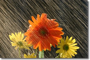
Weather Topic: What is Precipitation?
Home - Education - Precipitation - Precipitation
 Next Topic: Rain
Precipitation can refer to many different forms of water that
may fall from clouds. Precipitation occurs after a cloud has become saturated to
the point where its water particles are more dense than the air below the cloud.
In most cases, precipitation will reach the ground, but it is not uncommon for
precipitation to evaporate before it reaches the earth's surface.
When precipitation evaporates before it contacts the ground it is called Virga.
Graupel, hail, sleet, rain, drizzle, and snow are forms of precipitation, but fog
and mist are not considered precipitation because the water vapor which
constitutes them isn't dense enough to fall to the ground.
Next Topic: Rain
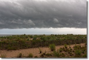
Weather Topic: What are Shelf Clouds?
Home - Education - Cloud Types - Shelf Clouds
 Next Topic: Sleet
A shelf cloud is similar to a wall cloud, but forms at the front
of a storm cloud, instead of at the rear, where wall clouds form.
A shelf cloud is caused by a series of events set into motion by the advancing
storm; first, cool air settles along the ground where precipitation has just fallen.
As the cool air is brought in, the warmer air is displaced, and rises above it,
because it is less dense. When the warmer air reaches the bottom of the storm cloud,
it begins to cool again, and the resulting condensation is a visible shelf cloud.
Next Topic: Sleet
Current conditions powered by WeatherAPI.com


