Weather Alert in Michigan
Flood Watch issued April 2 at 12:50PM EDT until April 7 at 2:00AM EDT by NWS Grand Rapids MI
AREAS AFFECTED: Newaygo
DESCRIPTION: ...The National Weather Service in Grand Rapids MI has issued a Flood Watch for the following rivers in Michigan... Muskegon River at Newaygo affecting Newaygo County. Muskegon River at Bridgeton affecting Newaygo County. .1 To 2 inches of rain has fallen in recent days, with an additional 1 to 2 inches expected over the next few days. The Muskegon River has begun to rise, and flooding may develop by this weekend. * WHAT...Flooding is possible. * WHERE...Muskegon River at Newaygo. * WHEN...From Saturday morning to early Tuesday morning. * IMPACTS...At 11.0 feet, The river starts exceeding its banks and minor flooding begins in low lying areas along the river. * ADDITIONAL DETAILS... - At 9:45 AM EDT Thursday the stage was 9.0 feet. - Forecast...Flood stage may be reached Saturday morning. - Flood stage is 11.0 feet. - http://www.weather.gov/safety/flood
INSTRUCTION: Residents and those with interests near the river should monitor rising water levels and be prepared for possible flood warnings. Stay tuned to further developments by listening to your local radio, television, or NOAA Weather Radio for further information. Additional information is available at www.weather.gov/grr.
Want more detail? Get the Complete 7 Day and Night Detailed Forecast!
Current U.S. National Radar--Current
The Current National Weather Radar is shown below with a UTC Time (subtract 5 hours from UTC to get Eastern Time).

National Weather Forecast--Current
The Current National Weather Forecast and National Weather Map are shown below.

National Weather Forecast for Tomorrow
Tomorrow National Weather Forecast and Tomorrow National Weather Map are show below.

North America Water Vapor (Moisture)
This map shows recent moisture content over North America. Bright and colored areas show high moisture (ie, clouds); brown indicates very little moisture present; black indicates no moisture.

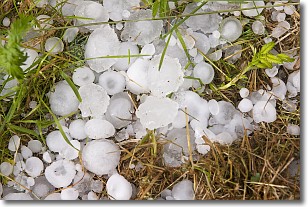
Weather Topic: What is Hail?
Home - Education - Precipitation - Hail
 Next Topic: Hole Punch Clouds
Hail is a form of precipitation which is recognized by large solid balls or
clumps of ice. Hail is created by thunderstorm clouds with strong updrafts of wind.
As the hailstones remain in the updraft, ice is deposited onto them until their
weight becomes heavy enough for them to fall to the earth's surface.
Hail storms can cause significant damage to crops, aircrafts, and man-made structures,
despite the fact that the duration is usually less than ten minutes.
Next Topic: Hole Punch Clouds
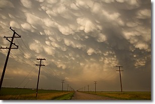
Weather Topic: What are Mammatus Clouds?
Home - Education - Cloud Types - Mammatus Clouds
 Next Topic: Nimbostratus Clouds
A mammatus cloud is a cloud with a unique feature which resembles
a web of pouches hanging along the base of the cloud.
In the United States, mammatus clouds tend to form in the warmer months, commonly
in the Midwest and eastern regions.
While they usually form at the bottom of a cumulonimbis cloud, they can also form
under altostratus, altocumulus, stratocumulus, and cirrus clouds. Mammatus clouds
warn that severe weather is close.
Next Topic: Nimbostratus Clouds
Current conditions powered by WeatherAPI.com


