Weather Alert in Oregon
Extreme Heat Warning issued August 22 at 4:52AM PDT until August 26 at 5:00AM PDT by NWS Portland OR
AREAS AFFECTED: Lower Columbia River; Tualatin Valley; West Hills and Chehalem Mountains; Inner Portland Metro; East Portland Metro; Outer Southeast Portland Metro; West Central Willamette Valley; East Central Willamette Valley; Benton County Lowlands; Linn County Lowlands; Lane County Lowlands; West Columbia River Gorge of Oregon above 500 ft; West Columbia River Gorge I-84 Corridor; Upper Hood River Valley; Central Columbia River Gorge I-84 Corridor; Clackamas County Cascade Foothills; Cascade Foothills of Marion and Linn Counties; Lane County Cascade Foothills; Cowlitz County Lowlands; North Clark County Lowlands; Inner Vancouver Metro; East Clark County Lowlands; South Washington Cascade Foothills; West Columbia River Gorge - SR 14; Central Columbia River Gorge - SR 14
DESCRIPTION: * WHAT...Dangerously hot conditions with high temperatures of 96-103F and overnight low temperatures of 60-70F expected, except low to mid 70s in the Columbia River Gorge. * WHERE...Greater Portland/Vancouver Metro, Western and Central Columbia River Gorge, the Corbett area and the Hood River Valley, Central and Southern Willamette Valley, Foothills of the Northern and Central Oregon Cascades, Lower Columbia River and Cowlitz River Valleys, and South Washington Cascade Foothills. * WHEN...From 11 AM this morning to 5 AM PDT Tuesday. * IMPACTS...Heat related illnesses increase significantly during extreme heat events, especially for those spending time outdoors or without access to adequate cooling. * ADDITIONAL DETAILS...Friday and Saturday will be the hottest days. The warmest overnight lows are expected to occur in the Columbia River Gorge and in urban areas from Salem northward.
INSTRUCTION: Drink plenty of fluids, stay in a cool place during the heat of the day, stay out of the sunshine, and check up on relatives and neighbors. For those without air conditioning, use fans to keep air moving. Keeps windows closed during the day and open at night, unless air quality is degraded due to wildfire smoke. Do not leave young children and pets in unattended vehicles. Car interiors will reach lethal temperatures in a matter of minutes. Take extra precautions when outside. Wear lightweight and loose fitting clothing. Try to limit strenuous activities to early morning or evening. Take action when you see symptoms of heat exhaustion and heat stroke.
Want more detail? Get the Complete 7 Day and Night Detailed Forecast!
Current U.S. National Radar--Current
The Current National Weather Radar is shown below with a UTC Time (subtract 5 hours from UTC to get Eastern Time).

National Weather Forecast--Current
The Current National Weather Forecast and National Weather Map are shown below.

National Weather Forecast for Tomorrow
Tomorrow National Weather Forecast and Tomorrow National Weather Map are show below.

North America Water Vapor (Moisture)
This map shows recent moisture content over North America. Bright and colored areas show high moisture (ie, clouds); brown indicates very little moisture present; black indicates no moisture.

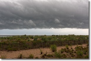
Weather Topic: What are Shelf Clouds?
Home - Education - Cloud Types - Shelf Clouds
 Next Topic: Sleet
A shelf cloud is similar to a wall cloud, but forms at the front
of a storm cloud, instead of at the rear, where wall clouds form.
A shelf cloud is caused by a series of events set into motion by the advancing
storm; first, cool air settles along the ground where precipitation has just fallen.
As the cool air is brought in, the warmer air is displaced, and rises above it,
because it is less dense. When the warmer air reaches the bottom of the storm cloud,
it begins to cool again, and the resulting condensation is a visible shelf cloud.
Next Topic: Sleet
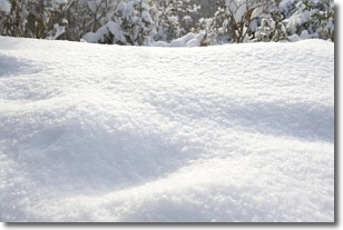
Weather Topic: What is Snow?
Home - Education - Precipitation - Snow
 Next Topic: Stratocumulus Clouds
Snow is precipitation taking the form of ice crystals. Each ice crystal, or snowflake,
has unique characteristics, but all of them grow in a hexagonal structure.
Snowfall can last for sustained periods of time and result in significant buildup
of snow on the ground.
On the earth's surface, snow starts out light and powdery, but as it begins to melt
it tends to become more granular, producing small bits of ice which have the consistency of
sand. After several cycles of melting and freezing, snow can become very dense
and ice-like, commonly known as snow pack.
Next Topic: Stratocumulus Clouds
Current conditions powered by WeatherAPI.com


