Weather Alert in Illinois
Flood Watch issued April 2 at 10:25AM CDT until April 5 at 7:00AM CDT by NWS Chicago IL
AREAS AFFECTED: Winnebago
DESCRIPTION: ...The National Weather Service in Chicago IL has issued a Flood Watch for the following rivers in Illinois... Kishwaukee River near Perryville affecting Winnebago County. For the Kishwaukee River...including Perryville...flooding is possible. * WHAT...Flooding is possible. * WHERE...Kishwaukee River from Confluence with South Branch Kishwaukee River downstream to the Rock River, including the Perryville gauge. * WHEN...From Friday evening to Sunday morning. * IMPACTS...At 12.0 feet, Water overtops low-lying banks in Blackhawk Springs Forest Preserve and in south Rockford near Chicago Rockford International Airport. Trails threatened at Blackhawk Springs Forest Preserve. * ADDITIONAL DETAILS... - At 9:30 AM CDT Thursday the stage was 6.6 feet. - Forecast...Flood stage may be reached late tomorrow afternoon or evening. - Flood stage is 12.0 feet. - http://www.weather.gov/safety/flood
INSTRUCTION: A Flood Watch means water levels above flood stage are possible, but not yet certain, based upon the latest forecasts. Persons along rivers and streams in the watch area should monitor the latest forecasts and be prepared to take action should flooding develop. These forecasts are based on observed precipitation as well as forecast precipitation 24 hours into the future. Changes to the rainfall forecast, or any additional rainfall after 24 hours, may cause changes to these river forecasts. Additional information is available at www.weather.gov. The next statement will be issued by late tonight.
Want more detail? Get the Complete 7 Day and Night Detailed Forecast!
Current U.S. National Radar--Current
The Current National Weather Radar is shown below with a UTC Time (subtract 5 hours from UTC to get Eastern Time).

National Weather Forecast--Current
The Current National Weather Forecast and National Weather Map are shown below.

National Weather Forecast for Tomorrow
Tomorrow National Weather Forecast and Tomorrow National Weather Map are show below.

North America Water Vapor (Moisture)
This map shows recent moisture content over North America. Bright and colored areas show high moisture (ie, clouds); brown indicates very little moisture present; black indicates no moisture.

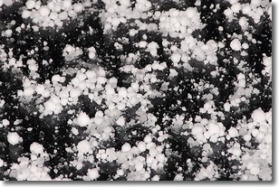
Weather Topic: What is Graupel?
Home - Education - Precipitation - Graupel
 Next Topic: Hail
Graupel is a form of precipitation that is created by atmospheric conditions
which cause supercooled water droplets to contact snow crystals and freeze to
their surface.
Sometimes known as soft hail or snow pellets, graupel is delicate and easily
destroyed by touch. Whereas hail usually falls during severe weather, graupel
doesn't require such conditions to form, and can form in mild precipitation
similar to situations which produce snowfall.
Next Topic: Hail
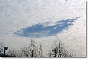
Weather Topic: What are Hole Punch Clouds?
Home - Education - Cloud Types - Hole Punch Clouds
 Next Topic: Mammatus Clouds
A hole punch cloud is an unusual occurrence when a disk-shaped
hole appears in a cirrostratus, cirrocumulus, or altocumulus cloud.
When part of the cloud forms ice crystals, water droplets in the surrounding area
of the cloud evaporate. The effect of this process produces a large elliptical
gap in the cloud. The hole punch cloud formation is rare, but it is not specific
to any geographic area.
Other names which have been used to describe this phenomena include fallstreak hole,
skypunch, and cloud hole.
Next Topic: Mammatus Clouds
Current conditions powered by WeatherAPI.com


