Weather Alert in Montana
Air Quality Alert issued September 3 at 8:55AM MDT by NWS Great Falls MT
AREAS AFFECTED: Flathead, MT; Glacier, MT; Lake, MT; Lincoln, MT; Mineral, MT; Missoula, MT; Powell, MT; Sanders, MT
DESCRIPTION: AQAMT The Montana Department of Environmental Quality has issued an air quality alert for Flathead, Lake, Lincoln, Mineral, Missoula, Powell, Sanders, Glacier counties in effect until 9AM on 09/04/2025 An Air Quality Alert means that particulates have been trending upwards and that an exceedence of the 24 hour National Ambient Air Quality Standard (NAAQS) has occurred or may occur in the near future. Elevated particulate levels from wildfire smoke As of 8AM on 09/03/2025, particulate levels in Great Falls are Unhealthy for Sensitive Groups. As of 8AM on 09/03/2025, particulate levels in Billings, Butte, Columbia Falls, Cut Bank, Glendive, Hamilton, Havre, Lewistown, Seeley Lake, Sidney and Thompson Falls are Moderate. When air quality is Unhealthy for Sensitive Groups... State and local health officials recommend that people with respiratory or heart disease, the elderly and children should limit prolonged exertion. When air quality is Moderate... State and local health officials recommend that unusually sensitive people should consider reducing prolonged or heavy exertion. For more information visit the Montana Department of Environmental Quality at http://todaysair.mtdeq.us
INSTRUCTION: N/A
Want more detail? Get the Complete 7 Day and Night Detailed Forecast!
Current U.S. National Radar--Current
The Current National Weather Radar is shown below with a UTC Time (subtract 5 hours from UTC to get Eastern Time).

National Weather Forecast--Current
The Current National Weather Forecast and National Weather Map are shown below.

National Weather Forecast for Tomorrow
Tomorrow National Weather Forecast and Tomorrow National Weather Map are show below.

North America Water Vapor (Moisture)
This map shows recent moisture content over North America. Bright and colored areas show high moisture (ie, clouds); brown indicates very little moisture present; black indicates no moisture.

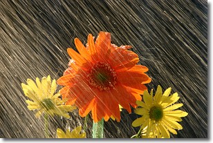
Weather Topic: What is Precipitation?
Home - Education - Precipitation - Precipitation
 Next Topic: Rain
Precipitation can refer to many different forms of water that
may fall from clouds. Precipitation occurs after a cloud has become saturated to
the point where its water particles are more dense than the air below the cloud.
In most cases, precipitation will reach the ground, but it is not uncommon for
precipitation to evaporate before it reaches the earth's surface.
When precipitation evaporates before it contacts the ground it is called Virga.
Graupel, hail, sleet, rain, drizzle, and snow are forms of precipitation, but fog
and mist are not considered precipitation because the water vapor which
constitutes them isn't dense enough to fall to the ground.
Next Topic: Rain
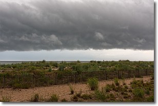
Weather Topic: What are Shelf Clouds?
Home - Education - Cloud Types - Shelf Clouds
 Next Topic: Sleet
A shelf cloud is similar to a wall cloud, but forms at the front
of a storm cloud, instead of at the rear, where wall clouds form.
A shelf cloud is caused by a series of events set into motion by the advancing
storm; first, cool air settles along the ground where precipitation has just fallen.
As the cool air is brought in, the warmer air is displaced, and rises above it,
because it is less dense. When the warmer air reaches the bottom of the storm cloud,
it begins to cool again, and the resulting condensation is a visible shelf cloud.
Next Topic: Sleet
Current conditions powered by WeatherAPI.com


