Weather Alert in Alaska
Hydrologic Outlook issued August 22 at 1:07PM AKDT by NWS Fairbanks AK
AREAS AFFECTED: Howard Pass and the Delong Mountains; Central Brooks Range; South Slopes Of The Central Brooks Range; South Slopes of the Western Brooks Range; Noatak Valley; Lower Kobuk Valley; Northern Seward Peninsula; Upper Kobuk Valleys; Southern Seward Peninsula Coast; Interior Seward Peninsula; Eastern Norton Sound and Nulato Hills; Lower Yukon River; Lower Koyukuk Valley; Middle Yukon Valley; Lower Yukon and Innoko Valleys; Upper Koyukuk Valley; Dalton Highway Summits; Central Interior
DESCRIPTION: ESFAFG Multiple waves of rainfall are expected starting Saturday and continuing through early next week with rainfall totals exceeding 3 inches in many areas of the middle Kuskokwim, middle and lower Yukon, Koyukuk, and Kobuk River basins. Expect increasing river levels on tributaries to these basins starting this weekend and rising water levels on the main stems starting early next week. Highest rainfall totals could exceed 5 inches in isolated areas, typically at higher elevations in the Nulato Hills and the Brooks Range.
INSTRUCTION: N/A
Want more detail? Get the Complete 7 Day and Night Detailed Forecast!
Current U.S. National Radar--Current
The Current National Weather Radar is shown below with a UTC Time (subtract 5 hours from UTC to get Eastern Time).

National Weather Forecast--Current
The Current National Weather Forecast and National Weather Map are shown below.

National Weather Forecast for Tomorrow
Tomorrow National Weather Forecast and Tomorrow National Weather Map are show below.

North America Water Vapor (Moisture)
This map shows recent moisture content over North America. Bright and colored areas show high moisture (ie, clouds); brown indicates very little moisture present; black indicates no moisture.

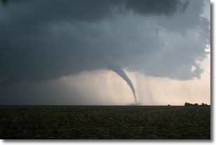
Weather Topic: What are Wall Clouds?
Home - Education - Cloud Types - Wall Clouds
 Next Topic: Altocumulus Clouds
A wall cloud forms underneath the base of a cumulonimbus cloud,
and can be a hotbed for deadly tornadoes.
Wall clouds are formed by air flowing into the cumulonimbus clouds, which can
result in the wall cloud descending from the base of the cumulonimbus cloud, or
rising fractus clouds which join to the base of the storm cloud as the wall cloud
takes shape.
Wall clouds can be very large, and in the Northern Hemisphere they generally
form at the southern edge of cumulonimbus clouds.
Next Topic: Altocumulus Clouds
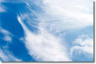
Weather Topic: What are Altostratus Clouds?
Home - Education - Cloud Types - Altostratus Clouds
 Next Topic: Cirrocumulus Clouds
Altostratus clouds form at mid to high-level altitudes
(between 2 and 7 km) and are created by a warm, stable air mass which causes
water vapor
to condense as it rise through the atmosphere. Usually altostratus clouds are
featureless sheets characterized by a uniform color.
In some cases, wind punching through the cloud formation may give it a waved
appearance, called altostratus undulatus. Altostratus clouds
are commonly seen with other cloud formations accompanying them.
Next Topic: Cirrocumulus Clouds
Current conditions powered by WeatherAPI.com


