Weather Alert in South Carolina
Flash Flood Warning issued August 22 at 1:04PM EDT until August 22 at 3:15PM EDT by NWS Charleston SC
AREAS AFFECTED: Berkeley, SC; Charleston, SC; Dorchester, SC
DESCRIPTION: FFWCHS The National Weather Service in Charleston has extended the * Flash Flood Warning for... Berkeley County in southeastern South Carolina... Charleston County in southeastern South Carolina... Dorchester County in southeastern South Carolina... * Until 315 PM EDT. * At 104 PM EDT, emergency management officials reported flash flooding is still ongoing across much of the Charleston Metro Area. Many roads are reported closed and flooded across Downtown Charleston, North Charleston and surrounding communities. While rainfall will continue to slowly diminish this afternoon, the risk for flash flooding continues. Up to an additional inch of rain could fall through 315 PM. Never drive around police barricades. HAZARD...Life threatening flash flooding. Thunderstorms producing flash flooding. SOURCE...Emergency management reported. IMPACT...Life threatening flash flooding of creeks and streams, urban areas, highways, streets and underpasses. * Some locations that will experience flash flooding include... North Charleston, Mount Pleasant, Goose Creek, Hanahan, West Ashley, Downtown Charleston, I-26/I-526 Interchange, James Island, Johns Island and Daniel Island. This includes the following highways... I-26 between mile markers 208 and 221. I-526 between mile markers 11 and 29.
INSTRUCTION: Turn around, don't drown when encountering flooded roads. Most flood deaths occur in vehicles. Report flooding directly to the Charleston National Weather Service at 1-888-383-2024 or email your reports to nws.charlestonsc@noaa.gov.
Want more detail? Get the Complete 7 Day and Night Detailed Forecast!
Current U.S. National Radar--Current
The Current National Weather Radar is shown below with a UTC Time (subtract 5 hours from UTC to get Eastern Time).

National Weather Forecast--Current
The Current National Weather Forecast and National Weather Map are shown below.

National Weather Forecast for Tomorrow
Tomorrow National Weather Forecast and Tomorrow National Weather Map are show below.

North America Water Vapor (Moisture)
This map shows recent moisture content over North America. Bright and colored areas show high moisture (ie, clouds); brown indicates very little moisture present; black indicates no moisture.

Weather Topic: What is Rain?
Home - Education - Precipitation - Rain
 Next Topic: Shelf Clouds
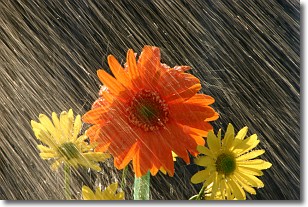
Precipitation in the form of water droplets is called rain.
Rain generally has a tendency to fall with less intensity over a greater period
of time, and when rainfall is more severe it is usually less sustained.
Rain is the most common form of precipitation and happens with greater frequency
depending on the season and regional influences. Cities have been shown to have
an observable effect on rainfall, due to an effect called the urban heat island.
Compared to upwind, monthly rainfall between twenty and forty miles downwind of
cities is 30% greater.
Next Topic: Shelf Clouds
Weather Topic: What is Sleet?
Home - Education - Precipitation - Sleet
 Next Topic: Snow
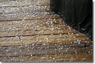
Sleet is a form of precipitation in which small ice pellets are the primary
components. These ice pellets are smaller and more translucent than hailstones,
and harder than graupel. Sleet is caused by specific atmospheric conditions and
therefore typically doesn't last for extended periods of time.
The condition which leads to sleet formation requires a warmer body of air to be
wedged in between two sub-freezing bodies of air. When snow falls through a warmer
layer of air it melts, and as it falls through the next sub-freezing body of air
it freezes again, forming ice pellets known as sleet. In some cases, water
droplets don't have time to freeze before reaching the surface and the result is
freezing rain.
Next Topic: Snow
Current conditions powered by WeatherAPI.com


