Weather Alert in District of Columbia
Heat Advisory issued June 26 at 2:25AM EDT until June 26 at 7:00PM EDT by NWS Baltimore MD/Washington DC
AREAS AFFECTED: District of Columbia; Washington; Frederick; Carroll; Northern Baltimore; Cecil; Southern Baltimore; Prince Georges; Anne Arundel; Charles; St. Marys; Calvert; Central and Eastern Allegany; Northwest Montgomery; Central and Southeast Montgomery; Northwest Howard; Central and Southeast Howard; Northwest Harford; Southeast Harford; Rockingham; Shenandoah; Frederick; Page; Warren; Clarke; Nelson; Albemarle; Greene; Madison; Rappahannock; Orange; Culpeper; Fairfax; Arlington/Falls Church/Alexandria; Stafford; Spotsylvania; King George; Northern Fauquier; Southern Fauquier; Western Loudoun; Eastern Loudoun; Northwest Prince William; Central and Southeast Prince William/Manassas/Manassas Park; Hampshire; Morgan; Berkeley; Jefferson; Hardy; Eastern Grant; Eastern Mineral
DESCRIPTION: * WHAT...For the Heat Advisory, heat index values up to 107 expected east of the Blue Ridge, and up to 103 west of the Blue Ridge. * WHERE...DC, central, north central, northeast, northern, southern, and western Maryland, central, northern, northwest, and western Virginia, and eastern and panhandle West Virginia. * WHEN...From 11 AM this morning to 7 PM EDT this evening. * IMPACTS...Hot temperatures and high humidity may cause heat illnesses.
INSTRUCTION: Drink plenty of fluids, stay in an air-conditioned room, stay out of the sun, and check up on relatives and neighbors. Take extra precautions when outside. Wear lightweight and loose fitting clothing. Try to limit strenuous activities to early morning or evening. Take action when you see symptoms of heat exhaustion and heat stroke.
Want more detail? Get the Complete 7 Day and Night Detailed Forecast!
Current U.S. National Radar--Current
The Current National Weather Radar is shown below with a UTC Time (subtract 5 hours from UTC to get Eastern Time).

National Weather Forecast--Current
The Current National Weather Forecast and National Weather Map are shown below.

National Weather Forecast for Tomorrow
Tomorrow National Weather Forecast and Tomorrow National Weather Map are show below.

North America Water Vapor (Moisture)
This map shows recent moisture content over North America. Bright and colored areas show high moisture (ie, clouds); brown indicates very little moisture present; black indicates no moisture.

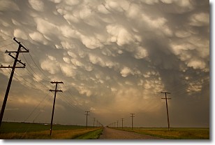
Weather Topic: What are Mammatus Clouds?
Home - Education - Cloud Types - Mammatus Clouds
 Next Topic: Nimbostratus Clouds
A mammatus cloud is a cloud with a unique feature which resembles
a web of pouches hanging along the base of the cloud.
In the United States, mammatus clouds tend to form in the warmer months, commonly
in the Midwest and eastern regions.
While they usually form at the bottom of a cumulonimbis cloud, they can also form
under altostratus, altocumulus, stratocumulus, and cirrus clouds. Mammatus clouds
warn that severe weather is close.
Next Topic: Nimbostratus Clouds
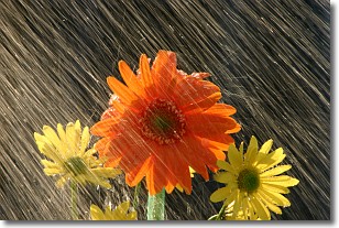
Weather Topic: What is Precipitation?
Home - Education - Precipitation - Precipitation
 Next Topic: Rain
Precipitation can refer to many different forms of water that
may fall from clouds. Precipitation occurs after a cloud has become saturated to
the point where its water particles are more dense than the air below the cloud.
In most cases, precipitation will reach the ground, but it is not uncommon for
precipitation to evaporate before it reaches the earth's surface.
When precipitation evaporates before it contacts the ground it is called Virga.
Graupel, hail, sleet, rain, drizzle, and snow are forms of precipitation, but fog
and mist are not considered precipitation because the water vapor which
constitutes them isn't dense enough to fall to the ground.
Next Topic: Rain
Current conditions powered by WeatherAPI.com


