Weather Alert in Washington
Hydrologic Outlook issued August 14 at 12:20PM PDT by NWS Seattle WA
AREAS AFFECTED: Clallam, WA; Grays Harbor, WA; Island, WA; Jefferson, WA; King, WA; Kitsap, WA; Lewis, WA; Mason, WA; Pierce, WA; San Juan, WA; Skagit, WA; Snohomish, WA; Thurston, WA; Whatcom, WA
DESCRIPTION: ESFSEW A frontal system will move across the area Friday into Saturday across western Washington. Through Saturday afternoon, 3-5 inches of rain are expected across the mountains, with 0.5-1.5 inches expected through the lowlands. Very dry antecedent conditions has left the area soils dry and hard. This amount of rainfall in one storm will not have much time to soak into the very dry soil, which will result in heavy surface runoff. Impacts are uncertain due to how much moisture will be able to be absorbed by the soil. Several different threats are expected with this storm, which are detailed below. *Urban and urban-like flooding will be possible in flat areas and roadways. *Some small streams and creeks may become swollen due to rapid runoff while others may remain lower if the channel bed is able to absorb the water efficiently. *Rivers will not flood, but will undergo rapid rises to unusually high levels for this time of year, some of which may reach daily record crests. This will pose a threat to those engaged in recreational activities in and along river channels. *Burn scars will have the potential to undergo impacts, but the probability is low. Impacts may include flash flooding, debris flows, rock falls, and other falling debris. *Those engaging in recreational activities in the mountains may face challenges to where high water may make forest roads and trails difficult to traverse. Please monitor the latest forecasts from the National Weather Service for additional information.
INSTRUCTION: N/A
Want more detail? Get the Complete 7 Day and Night Detailed Forecast!
Current U.S. National Radar--Current
The Current National Weather Radar is shown below with a UTC Time (subtract 5 hours from UTC to get Eastern Time).

National Weather Forecast--Current
The Current National Weather Forecast and National Weather Map are shown below.

National Weather Forecast for Tomorrow
Tomorrow National Weather Forecast and Tomorrow National Weather Map are show below.

North America Water Vapor (Moisture)
This map shows recent moisture content over North America. Bright and colored areas show high moisture (ie, clouds); brown indicates very little moisture present; black indicates no moisture.

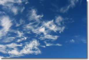
Weather Topic: What are Altostratus Clouds?
Home - Education - Cloud Types - Altostratus Clouds
 Next Topic: Cirrocumulus Clouds
Altostratus clouds form at mid to high-level altitudes
(between 2 and 7 km) and are created by a warm, stable air mass which causes
water vapor
to condense as it rise through the atmosphere. Usually altostratus clouds are
featureless sheets characterized by a uniform color.
In some cases, wind punching through the cloud formation may give it a waved
appearance, called altostratus undulatus. Altostratus clouds
are commonly seen with other cloud formations accompanying them.
Next Topic: Cirrocumulus Clouds
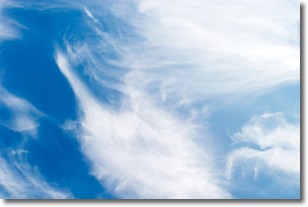
Weather Topic: What are Cirrostratus Clouds?
Home - Education - Cloud Types - Cirrostratus Clouds
 Next Topic: Cirrus Clouds
Cirrostratus clouds are high, thin clouds that form above
20,000 feet and are made mostly of ice crystals. They sometimes look like giant
feathers, horse tails, or curls of hair in the sky.
These clouds are pushed by the jet stream and can move at high speeds reaching
100 mph.
What do they indicate?
They indicate that a precipitation is likely within 24 hours.
Next Topic: Cirrus Clouds
Current conditions powered by WeatherAPI.com


