Weather Alert in Arizona
Flood Warning issued August 15 at 12:48AM MST until August 15 at 6:45AM MST by NWS Phoenix AZ
AREAS AFFECTED: Maricopa, AZ
DESCRIPTION: Rainfall has largely ended, however flooding of area streams and washes will continue overnight. * WHAT...Urban area and small stream flooding caused by excessive rainfall is expected. * WHERE...A portion of south central Arizona, including the following county, Maricopa. * WHEN...Until 645 AM MST. * IMPACTS...Flooding of rivers, creeks, streams, and other low-lying and flood-prone locations is imminent or occurring. Low-water crossings are inundated with water and may not be passable. * ADDITIONAL DETAILS... - At 1248 AM MST, Doppler radar and automated rain gauges indicated heavy rain due to thunderstorms. Flooding is already occurring in Indian Bend Wash. Between 1 and 2 inches of rain have fallen. - This includes the following streams and drainages... North Canyon Creek, New River, Skunk Creek, Indian Bend Wash, Cave Creek, Salt River, Apache Wash and Deadman Wash. Flooding impacts will continue, but no additional rainfall is expected. - Some locations that will experience flooding include... Phoenix, Glendale, Scottsdale, Tempe, Paradise Valley, New River, Cave Creek, Carefree, Desert Ridge Marketplace, Scottsdale Airport, Deer Valley Airport, Downtown Scottsdale and Salt River Indian Community. - http://www.weather.gov/safety/flood
INSTRUCTION: Turn around, don't drown when encountering flooded roads. Most flood deaths occur in vehicles. Be especially cautious at night when it is harder to recognize the dangers of flooding.
Want more detail? Get the Complete 7 Day and Night Detailed Forecast!
Current U.S. National Radar--Current
The Current National Weather Radar is shown below with a UTC Time (subtract 5 hours from UTC to get Eastern Time).

National Weather Forecast--Current
The Current National Weather Forecast and National Weather Map are shown below.

National Weather Forecast for Tomorrow
Tomorrow National Weather Forecast and Tomorrow National Weather Map are show below.

North America Water Vapor (Moisture)
This map shows recent moisture content over North America. Bright and colored areas show high moisture (ie, clouds); brown indicates very little moisture present; black indicates no moisture.

Weather Topic: What is Sleet?
Home - Education - Precipitation - Sleet
 Next Topic: Snow
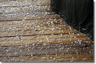
Sleet is a form of precipitation in which small ice pellets are the primary
components. These ice pellets are smaller and more translucent than hailstones,
and harder than graupel. Sleet is caused by specific atmospheric conditions and
therefore typically doesn't last for extended periods of time.
The condition which leads to sleet formation requires a warmer body of air to be
wedged in between two sub-freezing bodies of air. When snow falls through a warmer
layer of air it melts, and as it falls through the next sub-freezing body of air
it freezes again, forming ice pellets known as sleet. In some cases, water
droplets don't have time to freeze before reaching the surface and the result is
freezing rain.
Next Topic: Snow
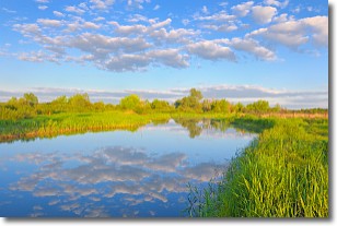
Weather Topic: What are Stratocumulus Clouds?
Home - Education - Cloud Types - Stratocumulus Clouds
 Next Topic: Stratus Clouds
Stratocumulus clouds are similar to altocumulus clouds in their
fluffy appearance, but have a slightly darker shade due to their additional mass.
A good way to distinguish the two cloud types is to hold your hand out and measure
the size of an individual cloud; if it is the size of your thumb it is generally
an altocumulus cloud, if it is the size of your hand it is generally a
stratocumulus cloud.
It is uncommon for stratocumulus clouds to produce precipitation, but if they do
it is usually a light rain or snow.
Next Topic: Stratus Clouds
Current conditions powered by WeatherAPI.com


