Weather Alert in Georgia
Air Quality Alert issued June 25 at 2:52PM EDT by NWS Peachtree City GA
AREAS AFFECTED: Dawson; Bartow; Cherokee; Forsyth; Hall; Paulding; Cobb; North Fulton; Gwinnett; Barrow; Carroll; Douglas; South Fulton; DeKalb; Rockdale; Walton; Newton; Coweta; Fayette; Clayton; Spalding; Henry; Pike
DESCRIPTION: AQAFFC The Georgia Department of Natural Resources, Environmental Protection Division has issued a Code Orange (Unhealthy for sensitive groups) Air Quality Alert for Atlanta for Thursday June 26. Under Code Orange conditions, the outdoor air quality is likely to be unhealthy for some people. Children, people who are sensitive to ozone, and people with heart or lung disease should limit prolonged outdoor exertion during the late afternoon or early evening when ozone concentrations are highest. For additional information on the Air Quality Index, please visit http://airnow.gov.
INSTRUCTION: N/A
Want more detail? Get the Complete 7 Day and Night Detailed Forecast!
Current U.S. National Radar--Current
The Current National Weather Radar is shown below with a UTC Time (subtract 5 hours from UTC to get Eastern Time).

National Weather Forecast--Current
The Current National Weather Forecast and National Weather Map are shown below.

National Weather Forecast for Tomorrow
Tomorrow National Weather Forecast and Tomorrow National Weather Map are show below.

North America Water Vapor (Moisture)
This map shows recent moisture content over North America. Bright and colored areas show high moisture (ie, clouds); brown indicates very little moisture present; black indicates no moisture.

Weather Topic: What is Hail?
Home - Education - Precipitation - Hail
 Next Topic: Hole Punch Clouds
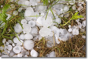
Hail is a form of precipitation which is recognized by large solid balls or
clumps of ice. Hail is created by thunderstorm clouds with strong updrafts of wind.
As the hailstones remain in the updraft, ice is deposited onto them until their
weight becomes heavy enough for them to fall to the earth's surface.
Hail storms can cause significant damage to crops, aircrafts, and man-made structures,
despite the fact that the duration is usually less than ten minutes.
Next Topic: Hole Punch Clouds
Weather Topic: What are Mammatus Clouds?
Home - Education - Cloud Types - Mammatus Clouds
 Next Topic: Nimbostratus Clouds
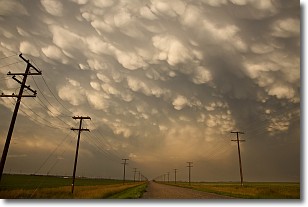
A mammatus cloud is a cloud with a unique feature which resembles
a web of pouches hanging along the base of the cloud.
In the United States, mammatus clouds tend to form in the warmer months, commonly
in the Midwest and eastern regions.
While they usually form at the bottom of a cumulonimbis cloud, they can also form
under altostratus, altocumulus, stratocumulus, and cirrus clouds. Mammatus clouds
warn that severe weather is close.
Next Topic: Nimbostratus Clouds
Current conditions powered by WeatherAPI.com


