Weather Alert in Wisconsin
Flood Watch issued April 4 at 9:48AM CDT until April 9 at 7:00PM CDT by NWS La Crosse WI
AREAS AFFECTED: Crawford
DESCRIPTION: ...The National Weather Service in La Crosse WI has issued a Flood Watch for the following rivers in Wisconsin... Kickapoo River at Soldiers Grove affecting Crawford County. Kickapoo River at Steuben affecting Crawford County. ...The Flood Watch is extended for the following rivers in Wisconsin... Yellow River at Necedah affecting Juneau County. * WHAT...Flooding is possible. * WHERE...Kickapoo River at Steuben. * WHEN...From late Monday night to Thursday evening. * IMPACTS...At 12.5 feet, Water reaches the bottom support beams of the bridge. * ADDITIONAL DETAILS... - At 8:45 AM CDT Saturday the stage was 11.2 feet. - Forecast...Flood stage may be reached early Tuesday morning. - Flood stage is 12.0 feet. - http://www.weather.gov/safety/flood
INSTRUCTION: Residents and those with interests near the river should monitor rising water levels and be prepared for possible flood warnings. If you are in the watch area, remain alert to possible flooding. Additional river and weather information is available at www.weather.gov/lacrosse. The next statement will be issued this afternoon by 300 PM CDT.
Want more detail? Get the Complete 7 Day and Night Detailed Forecast!
Current U.S. National Radar--Current
The Current National Weather Radar is shown below with a UTC Time (subtract 5 hours from UTC to get Eastern Time).

National Weather Forecast--Current
The Current National Weather Forecast and National Weather Map are shown below.

National Weather Forecast for Tomorrow
Tomorrow National Weather Forecast and Tomorrow National Weather Map are show below.

North America Water Vapor (Moisture)
This map shows recent moisture content over North America. Bright and colored areas show high moisture (ie, clouds); brown indicates very little moisture present; black indicates no moisture.

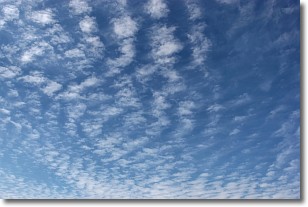
Weather Topic: What are Altocumulus Clouds?
Home - Education - Cloud Types - Altocumulus Clouds
 Next Topic: Altostratus Clouds
Similar to cirrocumulus clouds, altocumulus clouds are
characterized by cloud patches. They are distinguished by larger cloudlets
than cirrocumulus clouds but are still smaller than stratocumulus clouds.
Altocumulus clouds most commonly form in middle altitudes (between 2 and 5 km)
and may resemble, at times, the shape of a flying saucer.
These uncommon formations, called altocumulus lenticularis, are created by uplift
in the atmosphere and are most often seen in close proximity to mountains.
Next Topic: Altostratus Clouds
Weather Topic: What are Cirrocumulus Clouds?
Home - Education - Cloud Types - Cirrocumulus Clouds
 Next Topic: Cirrostratus Clouds
Cirrocumulus clouds form at high altitudes (usually around 5 km)
and have distinguishing characteristics displayed in a fine layer of
small cloud patches. These small cloud patches are sometimes referred to as
"cloudlets" in relation to the whole cloud formation.
Cirrocumulus clouds are formed from ice crystals and water droplets. Often, the
water droplets in the cloud freeze into ice crystals and the cloud becomes a
cirrostratus cloud. Because of this common occurrence, cirrocumulus cloud
formations generally pass rapidly.
Next Topic: Cirrostratus Clouds
Current conditions powered by WeatherAPI.com


