Weather Alert in Alaska
Flood Watch issued August 26 at 10:30PM AKDT until August 28 at 4:00PM AKDT by NWS Fairbanks AK
AREAS AFFECTED: South Slopes Of The Central Brooks Range; South Slopes of the Western Brooks Range; Upper Kobuk Valleys
DESCRIPTION: * WHAT...Flooding caused by excessive rainfall continues to be possible. * WHERE...Including the following areas, South Slopes of The Central Brooks Range, South Slopes of the Western Brooks Range and Upper Kobuk Valleys. This includes the cities of Wiseman, Coldfoot, Chandalar Dot Camp, Iniakuk Lake, The Dalton Highway From Mp 165 To Mp 232, Walker Lake, Ambler, Shungnak, And Kobuk. * WHEN...Through Thursday afternoon. * IMPACTS...Excessive runoff may result in flooding of rivers, creeks, streams, and other low-lying and flood-prone locations. Creeks and streams may rise out of their banks. Low-water crossings may be flooded. Area creeks and streams are running high and could flood with more heavy rain. * ADDITIONAL DETAILS... - Heavy rainfall of 3 to 6 inches has fallen across the watch area over the past couple of days. With an additional 1 to 2 inches of rainfall possible, a combination of saturated soils and runoff will allow for streams and creeks to continue running at elevated levels. Main stem rivers like the Koyukuk and Kobuk are forecast to see steady rises over the next couple of days with potential flooding issues along the Koyukuk near Allakaket as the river is expected to crest there Wednesday night into Thursday morning. - Http://www.weather.gov/aprfc
INSTRUCTION: Persons living along streams should stay alert and be prepared to take action if a warning or advisory is issued, or flooding is observed. You should monitor later forecasts and be alert for possible Flood Warnings. Those living in areas prone to flooding should be prepared to take action should flooding develop. Stay tuned to further developments by listening to your local radio, television, or NOAA Weather Radio for further information.
Want more detail? Get the Complete 7 Day and Night Detailed Forecast!
Current U.S. National Radar--Current
The Current National Weather Radar is shown below with a UTC Time (subtract 5 hours from UTC to get Eastern Time).

National Weather Forecast--Current
The Current National Weather Forecast and National Weather Map are shown below.

National Weather Forecast for Tomorrow
Tomorrow National Weather Forecast and Tomorrow National Weather Map are show below.

North America Water Vapor (Moisture)
This map shows recent moisture content over North America. Bright and colored areas show high moisture (ie, clouds); brown indicates very little moisture present; black indicates no moisture.

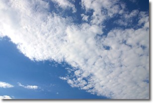
Weather Topic: What are Altocumulus Clouds?
Home - Education - Cloud Types - Altocumulus Clouds
 Next Topic: Altostratus Clouds
Similar to cirrocumulus clouds, altocumulus clouds are
characterized by cloud patches. They are distinguished by larger cloudlets
than cirrocumulus clouds but are still smaller than stratocumulus clouds.
Altocumulus clouds most commonly form in middle altitudes (between 2 and 5 km)
and may resemble, at times, the shape of a flying saucer.
These uncommon formations, called altocumulus lenticularis, are created by uplift
in the atmosphere and are most often seen in close proximity to mountains.
Next Topic: Altostratus Clouds
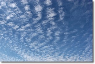
Weather Topic: What are Cirrocumulus Clouds?
Home - Education - Cloud Types - Cirrocumulus Clouds
 Next Topic: Cirrostratus Clouds
Cirrocumulus clouds form at high altitudes (usually around 5 km)
and have distinguishing characteristics displayed in a fine layer of
small cloud patches. These small cloud patches are sometimes referred to as
"cloudlets" in relation to the whole cloud formation.
Cirrocumulus clouds are formed from ice crystals and water droplets. Often, the
water droplets in the cloud freeze into ice crystals and the cloud becomes a
cirrostratus cloud. Because of this common occurrence, cirrocumulus cloud
formations generally pass rapidly.
Next Topic: Cirrostratus Clouds
Current conditions powered by WeatherAPI.com


