Weather Alert in California
Fire Weather Watch issued August 31 at 6:18PM PDT until September 2 at 8:00PM PDT by NWS Eureka CA
AREAS AFFECTED: Lower Middle Klamath; W Mendocino NF/E Mendocino Unit; Trinity
DESCRIPTION: ...ISOLATED DRY THUNDERSTORMS TUESDAY AFTERNOON AND EARLY EVENING... .Isolated dry thunderstorms are expected over the interior high terrain Tuesday afternoon and into early evening. Threats include erratic gusty winds and lightning. Lightning on dry fuels may lead to new fire starts. In addition, gusty winds combined with hot temperatures and low relative humidity will produce critical fire weather conditions. Existing fires and any new fire will have the potential to spread rapidly. * AFFECTED AREA...Fire weather zone 204.Fire weather zone 277.Fire weather zone 283. * THUNDERSTORMS...Isolated dry storms over high terrain in the afternoon and early evening hours. * OUTFLOW WINDS...Gusty and erratic outflow winds over 35 mph. * IMPACTS...any fires that develop will likely spread rapidly. Outdoor burning is not recommended.
INSTRUCTION: A Fire Weather Watch means that critical fire weather conditions are forecast to occur. Listen for later forecasts and possible Red Flag Warnings.
Want more detail? Get the Complete 7 Day and Night Detailed Forecast!
Current U.S. National Radar--Current
The Current National Weather Radar is shown below with a UTC Time (subtract 5 hours from UTC to get Eastern Time).

National Weather Forecast--Current
The Current National Weather Forecast and National Weather Map are shown below.

National Weather Forecast for Tomorrow
Tomorrow National Weather Forecast and Tomorrow National Weather Map are show below.

North America Water Vapor (Moisture)
This map shows recent moisture content over North America. Bright and colored areas show high moisture (ie, clouds); brown indicates very little moisture present; black indicates no moisture.

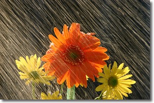
Weather Topic: What is Precipitation?
Home - Education - Precipitation - Precipitation
 Next Topic: Rain
Precipitation can refer to many different forms of water that
may fall from clouds. Precipitation occurs after a cloud has become saturated to
the point where its water particles are more dense than the air below the cloud.
In most cases, precipitation will reach the ground, but it is not uncommon for
precipitation to evaporate before it reaches the earth's surface.
When precipitation evaporates before it contacts the ground it is called Virga.
Graupel, hail, sleet, rain, drizzle, and snow are forms of precipitation, but fog
and mist are not considered precipitation because the water vapor which
constitutes them isn't dense enough to fall to the ground.
Next Topic: Rain
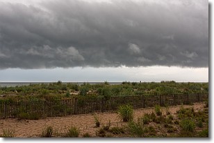
Weather Topic: What are Shelf Clouds?
Home - Education - Cloud Types - Shelf Clouds
 Next Topic: Sleet
A shelf cloud is similar to a wall cloud, but forms at the front
of a storm cloud, instead of at the rear, where wall clouds form.
A shelf cloud is caused by a series of events set into motion by the advancing
storm; first, cool air settles along the ground where precipitation has just fallen.
As the cool air is brought in, the warmer air is displaced, and rises above it,
because it is less dense. When the warmer air reaches the bottom of the storm cloud,
it begins to cool again, and the resulting condensation is a visible shelf cloud.
Next Topic: Sleet
Current conditions powered by WeatherAPI.com


