Weather Alert in California
Fire Weather Watch issued August 24 at 12:05AM PDT until August 25 at 11:00PM PDT by NWS Eureka CA
AREAS AFFECTED: Trinity
DESCRIPTION: ...SCATTERED DRY THUNDERSTORMS EACH AFTERNOON EARLY THIS WEEK... .Scattered dry thunderstorms expected over high terrain each afternoon early this week. Some isolated storms possible as early as Sunday afternoon with increasing storm coverage through Tuesday as far south as northern Lake County. Fuels are very dry on the heels of high heat. The National Weather Service in Eureka has issued a Fire Weather Watch, which is in effect from Monday afternoon through Monday evening. * AFFECTED AREA...Fire weather zone 283, Northern Trinity County. * THUNDERSTORMS...Mostly dry storms over high terrain in the late afternoon and evening. * OUTFLOW WINDS...Gusty and erratic outflow winds over 40 mph. * IMPACTS...any fires that develop will likely spread rapidly. Outdoor burning is not recommended.
INSTRUCTION: A Fire Weather Watch means that critical fire weather conditions are forecast to occur. Listen for later forecasts and possible Red Flag Warnings.
Want more detail? Get the Complete 7 Day and Night Detailed Forecast!
Current U.S. National Radar--Current
The Current National Weather Radar is shown below with a UTC Time (subtract 5 hours from UTC to get Eastern Time).

National Weather Forecast--Current
The Current National Weather Forecast and National Weather Map are shown below.

National Weather Forecast for Tomorrow
Tomorrow National Weather Forecast and Tomorrow National Weather Map are show below.

North America Water Vapor (Moisture)
This map shows recent moisture content over North America. Bright and colored areas show high moisture (ie, clouds); brown indicates very little moisture present; black indicates no moisture.

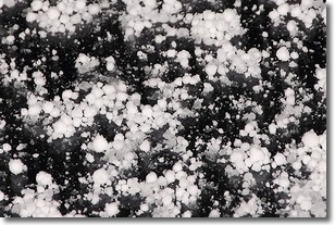
Weather Topic: What is Graupel?
Home - Education - Precipitation - Graupel
 Next Topic: Hail
Graupel is a form of precipitation that is created by atmospheric conditions
which cause supercooled water droplets to contact snow crystals and freeze to
their surface.
Sometimes known as soft hail or snow pellets, graupel is delicate and easily
destroyed by touch. Whereas hail usually falls during severe weather, graupel
doesn't require such conditions to form, and can form in mild precipitation
similar to situations which produce snowfall.
Next Topic: Hail
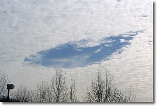
Weather Topic: What are Hole Punch Clouds?
Home - Education - Cloud Types - Hole Punch Clouds
 Next Topic: Mammatus Clouds
A hole punch cloud is an unusual occurrence when a disk-shaped
hole appears in a cirrostratus, cirrocumulus, or altocumulus cloud.
When part of the cloud forms ice crystals, water droplets in the surrounding area
of the cloud evaporate. The effect of this process produces a large elliptical
gap in the cloud. The hole punch cloud formation is rare, but it is not specific
to any geographic area.
Other names which have been used to describe this phenomena include fallstreak hole,
skypunch, and cloud hole.
Next Topic: Mammatus Clouds
Current conditions powered by WeatherAPI.com


