Weather Alert in Alaska
Flood Advisory issued September 4 at 12:36PM AKDT until September 6 at 12:00PM AKDT by NWS Fairbanks AK
AREAS AFFECTED: Upper Koyukuk Valley
DESCRIPTION: * WHAT...Flooding caused by excessive rainfall continues. * WHERE...Koyukuk River near Allakaket. * WHEN...Until noon AKDT Saturday. * IMPACTS...Minor flooding in low-lying and poorly drained areas. * ADDITIONAL DETAILS... - For the duration of this event there have been reports of some low lying roads being inundated. - The streamgage on the Koyukuk River below the John River shows water levels have been fluctuating less that a foot over the last 5 days and are not showing a rising or dropping trend. Though rain is still falling in areas on the south side of the Brooks Range, upstream locations (Slate Creek and the Middle and South Forks of the Koyukuk River) are not showing significant increases in response. Water levels are expected to remain steady at Allakaket for the next few days. - Http://www.weather.gov/aprfc
INSTRUCTION: N/A
Want more detail? Get the Complete 7 Day and Night Detailed Forecast!
Current U.S. National Radar--Current
The Current National Weather Radar is shown below with a UTC Time (subtract 5 hours from UTC to get Eastern Time).

National Weather Forecast--Current
The Current National Weather Forecast and National Weather Map are shown below.

National Weather Forecast for Tomorrow
Tomorrow National Weather Forecast and Tomorrow National Weather Map are show below.

North America Water Vapor (Moisture)
This map shows recent moisture content over North America. Bright and colored areas show high moisture (ie, clouds); brown indicates very little moisture present; black indicates no moisture.

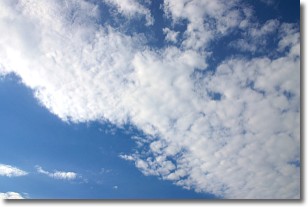
Weather Topic: What are Stratus Clouds?
Home - Education - Cloud Types - Stratus Clouds
 Next Topic: Wall Clouds
Stratus clouds are similar to altostratus clouds, but form at a
lower altitude and are identified by their fog-like appearance, lacking the
distinguishing features of most clouds.
Stratus clouds are wider than most clouds, and their base has a smooth, uniform
look which is lighter in color than a nimbostratus cloud.
The presence of a stratus cloud indicates the possibility of minor precipitation,
such as drizzle, but heavier precipitation does not typically arrive in the form
of a stratus cloud.
Next Topic: Wall Clouds
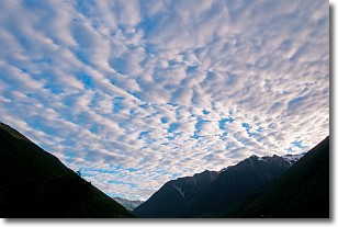
Weather Topic: What are Altocumulus Clouds?
Home - Education - Cloud Types - Altocumulus Clouds
 Next Topic: Altostratus Clouds
Similar to cirrocumulus clouds, altocumulus clouds are
characterized by cloud patches. They are distinguished by larger cloudlets
than cirrocumulus clouds but are still smaller than stratocumulus clouds.
Altocumulus clouds most commonly form in middle altitudes (between 2 and 5 km)
and may resemble, at times, the shape of a flying saucer.
These uncommon formations, called altocumulus lenticularis, are created by uplift
in the atmosphere and are most often seen in close proximity to mountains.
Next Topic: Altostratus Clouds
Current conditions powered by WeatherAPI.com


