Weather Alert in Oregon
Red Flag Warning issued September 5 at 1:38PM MDT until September 5 at 10:00PM MDT by NWS Boise ID
AREAS AFFECTED: Steens Mountain; Southern Grasslands
DESCRIPTION: ...RED FLAG WARNING FOR SOUTHEAST OREGON DUE TO ABUNDANT LIGHTNING AND GUSTY THUNDERSTORM OUTFLOWS THIS AFTERNOON AND EVENING... .Scattered thunderstorms capable of producing abundant lightning are forecast Friday afternoon and evening over southeastern Oregon. Gusty outflows to 50 mph may continue well into the evening and travel a large distance away from thunderstorms. The National Weather Service in Boise has issued a Red Flag Warning for lightning, which is in effect until 9 PM PDT this evening. * AFFECTED AREA...In Oregon, Fire Weather Zones 671 Steens Mountain and 672 Southern Grasslands. * TIMING...Until 9 PM PDT this evening. * THUNDERSTORMS...Scattered coverage with abundant lightning. * OUTFLOW WINDS...Gusty erratic winds up to 50 MPH. * IMPACTS...Any fire that develops will catch and spread quickly. Outdoor burning is not recommended.
INSTRUCTION: A Red Flag Warning means that critical fire weather conditions are either occurring now, or will occur shortly.
Want more detail? Get the Complete 7 Day and Night Detailed Forecast!
Current U.S. National Radar--Current
The Current National Weather Radar is shown below with a UTC Time (subtract 5 hours from UTC to get Eastern Time).

National Weather Forecast--Current
The Current National Weather Forecast and National Weather Map are shown below.

National Weather Forecast for Tomorrow
Tomorrow National Weather Forecast and Tomorrow National Weather Map are show below.

North America Water Vapor (Moisture)
This map shows recent moisture content over North America. Bright and colored areas show high moisture (ie, clouds); brown indicates very little moisture present; black indicates no moisture.

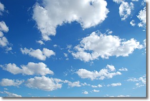
Weather Topic: What are Cumulonimbus Clouds?
Home - Education - Cloud Types - Cumulonimbus Clouds
 Next Topic: Cumulus Clouds
The final form taken by a growing cumulus cloud is the
cumulonimbus cloud, which is very tall and dense.
The tower of a cumulonimbus cloud can soar 23 km into the atmosphere, although
most commonly they stop growing at an altitude of 6 km.
Even small cumulonimbus clouds appear very large in comparison to other cloud types.
They can signal the approach of stormy weather, such as thunderstorms or blizzards.
Next Topic: Cumulus Clouds
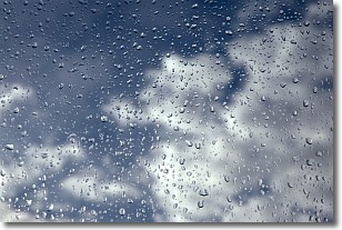
Weather Topic: What is Drizzle?
Home - Education - Precipitation - Drizzle
 Next Topic: Evaporation
Drizzle is precipitation in the form of water droplets which are
smaller than raindrops.
Drizzle is characterized by fine, gently falling droplets and typically does not
impact human habitation in a negative way. The exception to this is freezing drizzle,
a condition where drizzle freezes immediately upon reaching earth's surface.
Freezing drizzle is still less dangerous than freezing rain, but can
potentially result in hazardous road conditions.
Next Topic: Evaporation
Current conditions powered by WeatherAPI.com


