Weather Alert in South Carolina
Flash Flood Warning issued August 23 at 7:13AM EDT until August 23 at 10:15AM EDT by NWS Charleston SC
AREAS AFFECTED: Charleston, SC
DESCRIPTION: FFWCHS The National Weather Service in Charleston has issued a * Flash Flood Warning for... Charleston County in southeastern South Carolina... * Until 1015 AM EDT. * At 713 AM EDT, Doppler radar and automated rain gauges indicated showers and thunderstorms producing heavy rain across the warned area. Between 0.5 and 1 inch of rain has fallen across an area from the City of Charleston to James Island north to Shadowmoss. Additional rainfall amounts of 1 to 2 inches are possible in the warned area. Flash flooding is ongoing or expected to begin shortly. In addition, Church Creek near West Ashley may rise above flood stage this morning. HAZARD...Flash flooding caused by thunderstorms. SOURCE...Radar and automated gauges. IMPACT...Flash flooding of small creeks and streams, urban areas, highways, streets and underpasses as well as other poor drainage and low-lying areas. * Some locations that will experience flash flooding include... North Charleston, West Ashley, Downtown Charleston, James Island, Johns Island, Maybank Bridge, Charles Towne Landing, James Island County Park and Charleston Naval Complex.
INSTRUCTION: Turn around, don't drown when encountering flooded roads. Most flood deaths occur in vehicles. High tide will inhibit runoff of heavy rain, flooding areas of poor drainage in Downtown Charleston. Areas most prone to flooding include the Market, Crosstown, East Bay Street and Morrison Drive.
Want more detail? Get the Complete 7 Day and Night Detailed Forecast!
Current U.S. National Radar--Current
The Current National Weather Radar is shown below with a UTC Time (subtract 5 hours from UTC to get Eastern Time).

National Weather Forecast--Current
The Current National Weather Forecast and National Weather Map are shown below.

National Weather Forecast for Tomorrow
Tomorrow National Weather Forecast and Tomorrow National Weather Map are show below.

North America Water Vapor (Moisture)
This map shows recent moisture content over North America. Bright and colored areas show high moisture (ie, clouds); brown indicates very little moisture present; black indicates no moisture.

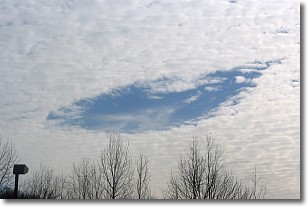
Weather Topic: What are Hole Punch Clouds?
Home - Education - Cloud Types - Hole Punch Clouds
 Next Topic: Mammatus Clouds
A hole punch cloud is an unusual occurrence when a disk-shaped
hole appears in a cirrostratus, cirrocumulus, or altocumulus cloud.
When part of the cloud forms ice crystals, water droplets in the surrounding area
of the cloud evaporate. The effect of this process produces a large elliptical
gap in the cloud. The hole punch cloud formation is rare, but it is not specific
to any geographic area.
Other names which have been used to describe this phenomena include fallstreak hole,
skypunch, and cloud hole.
Next Topic: Mammatus Clouds
Weather Topic: What are Nimbostratus Clouds?
Home - Education - Cloud Types - Nimbostratus Clouds
 Next Topic: Precipitation
A nimbostratus cloud is similar to a stratus cloud in its formless,
smooth appearance. However, a nimbostratus cloud is darker than a stratus cloud,
because it is thicker.
Unlike a stratus cloud, a nimbostratus cloud typically brings with it the threat
of moderate to heavy precipitation. In some cases, the precipitation may evaporate
before reaching the ground, a phenomenon known as virga.
Next Topic: Precipitation
Current conditions powered by WeatherAPI.com


