Weather Alert in New Mexico
Flood Watch issued September 11 at 12:33PM MDT until September 13 at 12:00AM MDT by NWS Albuquerque NM
AREAS AFFECTED: Northwest Plateau; Far Northwest Highlands; Northwest Highlands; West Central Mountains; West Central Highlands; Tusas Mountains Including Chama; Jemez Mountains; Glorieta Mesa Including Glorieta Pass; Northern Sangre de Cristo Mountains; Southern Sangre de Cristo Mountains; East Slopes Sangre de Cristo Mountains; Upper Rio Grande Valley; Espanola Valley; Santa Fe Metro Area; Middle Rio Grande Valley/Albuquerque Metro Area; Sandia/Manzano Mountains Including Edgewood
DESCRIPTION: * WHAT...Flash flooding caused by excessive rainfall is possible. * WHERE...Portions of central, north central, northwest, and west central New Mexico, including the following areas, in central New Mexico, Middle Rio Grande Valley including the Albuquerque Metro Area and Sandia and Manzano Mountains including Edgewood. In north central New Mexico, East Slopes Sangre de Cristo Mountains, Espanola Valley, Far Northwest Highlands, Glorieta Mesa Including Glorieta Pass, Jemez Mountains, Northern Sangre de Cristo Mountains, Northwest Highlands, Santa Fe Metro Area, Southern Sangre de Cristo Mountains, Tusas Mountains Including Chama and Upper Rio Grande Valley. In northwest New Mexico, Northwest Plateau. In west central New Mexico, West Central Highlands and West Central Mountains. * WHEN...From Friday morning through Friday evening. * IMPACTS...Excessive runoff may result in flooding of rivers, creeks, streams, and other low-lying and flood-prone locations. * ADDITIONAL DETAILS... - A disturbance ahead of a Pacific cold front will create training storms along northwest, west-central, central, and north-central New Mexico. Multiple rounds of thunderstorms may create accumulations up to 2 inches of rainfall. Strong thunderstorms will create locally heavy rainfall rates of 1 to 2 inches per hour. Storms look to persist for several hours, particularly late into the evening hours on Friday along the middle Rio Grande Valley and the north-central mountains. - http://www.weather.gov/safety/flood
INSTRUCTION: You should monitor later forecasts and be prepared to take action should Flash Flood Warnings be issued. Turn around, don't drown when encountering flooded roads. Most flood deaths occur in vehicles.
Want more detail? Get the Complete 7 Day and Night Detailed Forecast!
Current U.S. National Radar--Current
The Current National Weather Radar is shown below with a UTC Time (subtract 5 hours from UTC to get Eastern Time).

National Weather Forecast--Current
The Current National Weather Forecast and National Weather Map are shown below.

National Weather Forecast for Tomorrow
Tomorrow National Weather Forecast and Tomorrow National Weather Map are show below.

North America Water Vapor (Moisture)
This map shows recent moisture content over North America. Bright and colored areas show high moisture (ie, clouds); brown indicates very little moisture present; black indicates no moisture.

Weather Topic: What are Fractus Clouds?
Home - Education - Cloud Types - Fractus Clouds
 Next Topic: Freezing Rain
A fractus cloud (scud) is a fragmented, tattered cloud which has
likely been sheared off of another cloud. They are accessory clouds, meaning they
develop from parent clouds, and are named in a way which describes the original
cloud which contained them.
Fractus clouds which have originated from cumulus clouds are referred to as
cumulus fractus, while fractus clouds which have originated from stratus clouds
are referred to as stratus fractus. Under certain conditions a fractus cloud might
merge with another cloud, or develop into a cumulus cloud, but usually a
fractus cloud seen by itself will dissipate rapidly.
They are often observed on the leading and trailing edges of storm clouds,
and are a display of wind activity.
Next Topic: Freezing Rain
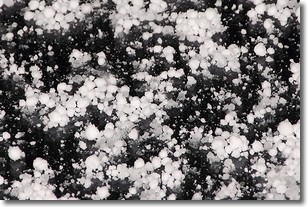
Weather Topic: What is Graupel?
Home - Education - Precipitation - Graupel
 Next Topic: Hail
Graupel is a form of precipitation that is created by atmospheric conditions
which cause supercooled water droplets to contact snow crystals and freeze to
their surface.
Sometimes known as soft hail or snow pellets, graupel is delicate and easily
destroyed by touch. Whereas hail usually falls during severe weather, graupel
doesn't require such conditions to form, and can form in mild precipitation
similar to situations which produce snowfall.
Next Topic: Hail
Current conditions powered by WeatherAPI.com


