Weather Alert in Arizona
Flood Watch issued August 14 at 1:27PM MST until August 15 at 8:00PM MST by NWS Flagstaff AZ
AREAS AFFECTED: Kaibab Plateau; Marble and Glen Canyons; Grand Canyon Country
DESCRIPTION: * WHAT...Flash flooding caused by excessive rainfall is possible. * WHERE...A portion of north central Arizona, including the following areas, Grand Canyon Country, Kaibab Plateau and Marble and Glen Canyons. This includes the Dragon Bravo and White Sage burn areas. * WHEN...From Friday morning through Friday evening. * IMPACTS...Flash flooding will be possible in creeks, normally dry washes, and over recently burned areas. There is a risk of debris flows downstream of recently burned areas. * ADDITIONAL DETAILS... - A series of slow moving thunderstorms with heavy rainfall are possible over recently burned areas on the Kaibab Plateau. - Additional information is available at weather.gov/flagstaff.
INSTRUCTION: Have multiple ways to receive Flash Flood Warnings and be prepared to take action should warnings be issued. Consider changing your plans if you are going to be in an area susceptible to flash flooding, such as creeks, streams, washes, slot canyons, campsites, or recently burned areas.
Want more detail? Get the Complete 7 Day and Night Detailed Forecast!
Current U.S. National Radar--Current
The Current National Weather Radar is shown below with a UTC Time (subtract 5 hours from UTC to get Eastern Time).

National Weather Forecast--Current
The Current National Weather Forecast and National Weather Map are shown below.

National Weather Forecast for Tomorrow
Tomorrow National Weather Forecast and Tomorrow National Weather Map are show below.

North America Water Vapor (Moisture)
This map shows recent moisture content over North America. Bright and colored areas show high moisture (ie, clouds); brown indicates very little moisture present; black indicates no moisture.

Weather Topic: What is Freezing Rain?
Home - Education - Precipitation - Freezing Rain
 Next Topic: Graupel
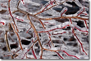
Freezing rain is a condition where precipitation which has fallen in the form of
water droplets reaches temperatures which are below freezing and freezes upon
coming into contact
with surface objects. The result of this precipitation is a glaze of ice which
can be damaging to plants and man-made structures. A severe onset of freezing
rain which results in a very thick glaze of ice is known as an ice storm.
Next Topic: Graupel
Weather Topic: What is Hail?
Home - Education - Precipitation - Hail
 Next Topic: Hole Punch Clouds
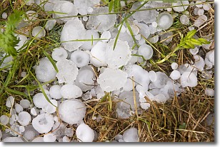
Hail is a form of precipitation which is recognized by large solid balls or
clumps of ice. Hail is created by thunderstorm clouds with strong updrafts of wind.
As the hailstones remain in the updraft, ice is deposited onto them until their
weight becomes heavy enough for them to fall to the earth's surface.
Hail storms can cause significant damage to crops, aircrafts, and man-made structures,
despite the fact that the duration is usually less than ten minutes.
Next Topic: Hole Punch Clouds
Current conditions powered by WeatherAPI.com


