Weather Alert in Oregon
Special Weather Statement issued August 22 at 1:26AM PDT by NWS Portland OR
AREAS AFFECTED: East Portland Metro; West Columbia River Gorge of Oregon above 500 ft; West Columbia River Gorge I-84 Corridor; Central Columbia River Gorge I-84 Corridor; East Clark County Lowlands; West Columbia River Gorge - SR 14; Central Columbia River Gorge - SR 14; South Washington Cascades
DESCRIPTION: Breezy easterly winds are expected through Friday night for the Columbia River Gorge and adjacent Cascade ridgetops and late Friday morning through Friday evening for the eastern Portland/Vancouver metro. Winds will be strongest on exposed ridgetops where wind gusts will most likely peak between 25-35 mph. Elsewhere, expect wind gusts between 15-20 mph, except up to 30 mph in the western Columbia River Gorge. The breezy east winds will occur simultaneously with low relative humidity values of 20-30% or less, resulting in near critical fire weather conditions. Due to recent rains in the area, larger fuels (such as trees and shrubs) are not dry enough to cause rapid fire spread, but the hot weather will allow fine fuels (such as grasses) to dry out quickly, allowing for potential rapid spread. Use extra caution with potential ignition sources, especially in grassy areas. Outdoor burning is not recommended.
INSTRUCTION: N/A
Want more detail? Get the Complete 7 Day and Night Detailed Forecast!
Current U.S. National Radar--Current
The Current National Weather Radar is shown below with a UTC Time (subtract 5 hours from UTC to get Eastern Time).

National Weather Forecast--Current
The Current National Weather Forecast and National Weather Map are shown below.

National Weather Forecast for Tomorrow
Tomorrow National Weather Forecast and Tomorrow National Weather Map are show below.

North America Water Vapor (Moisture)
This map shows recent moisture content over North America. Bright and colored areas show high moisture (ie, clouds); brown indicates very little moisture present; black indicates no moisture.

Weather Topic: What is Freezing Rain?
Home - Education - Precipitation - Freezing Rain
 Next Topic: Graupel
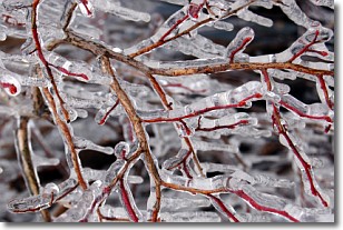
Freezing rain is a condition where precipitation which has fallen in the form of
water droplets reaches temperatures which are below freezing and freezes upon
coming into contact
with surface objects. The result of this precipitation is a glaze of ice which
can be damaging to plants and man-made structures. A severe onset of freezing
rain which results in a very thick glaze of ice is known as an ice storm.
Next Topic: Graupel
Weather Topic: What is Hail?
Home - Education - Precipitation - Hail
 Next Topic: Hole Punch Clouds
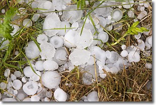
Hail is a form of precipitation which is recognized by large solid balls or
clumps of ice. Hail is created by thunderstorm clouds with strong updrafts of wind.
As the hailstones remain in the updraft, ice is deposited onto them until their
weight becomes heavy enough for them to fall to the earth's surface.
Hail storms can cause significant damage to crops, aircrafts, and man-made structures,
despite the fact that the duration is usually less than ten minutes.
Next Topic: Hole Punch Clouds
Current conditions powered by WeatherAPI.com


