Weather Alert in Michigan
Hydrologic Outlook issued April 4 at 2:12PM EDT by NWS Grand Rapids MI
AREAS AFFECTED: Allegan, MI; Barry, MI; Calhoun, MI; Clare, MI; Clinton, MI; Eaton, MI; Gratiot, MI; Ingham, MI; Ionia, MI; Isabella, MI; Jackson, MI; Kalamazoo, MI; Kent, MI; Lake, MI; Mason, MI; Mecosta, MI; Montcalm, MI; Muskegon, MI; Newaygo, MI; Oceana, MI; Osceola, MI; Ottawa, MI; Van Buren, MI
DESCRIPTION: ESFGRR Rainfall totals of 1-3 inches across the area this morning led to areas of areal flooding and ponding on roads, particularly for the Lansing area and Mount Pleasant areas. Additional rainfall to around 0.25" is expected through this evening for most, though totals to around 1" are possible for areas south and east of a Grand Rapids to Alma line in any thunderstorms this afternoon. This will likely slow drainage of ongoing flooding, and may result in the need for additional flood advisories if thunderstorms track over flood prone areas. Many area rivers and streams have seen rises as a result of the heavy rainfall. River Flood Warnings and Watches are in effect for numerous river forecast points across the area as the waters make their way through our river systems. Refer to those products for the latest information on river flooding. Numerous others are forecast to reach bankfull, with the Muskegon River at Evart coming particularly close to minor flood stage. For any type of flooding, avoid driving through flood waters. Turn around, don't drown!
INSTRUCTION: N/A
Want more detail? Get the Complete 7 Day and Night Detailed Forecast!
Current U.S. National Radar--Current
The Current National Weather Radar is shown below with a UTC Time (subtract 5 hours from UTC to get Eastern Time).

National Weather Forecast--Current
The Current National Weather Forecast and National Weather Map are shown below.

National Weather Forecast for Tomorrow
Tomorrow National Weather Forecast and Tomorrow National Weather Map are show below.

North America Water Vapor (Moisture)
This map shows recent moisture content over North America. Bright and colored areas show high moisture (ie, clouds); brown indicates very little moisture present; black indicates no moisture.

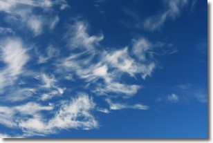
Weather Topic: What are Cirrostratus Clouds?
Home - Education - Cloud Types - Cirrostratus Clouds
 Next Topic: Cirrus Clouds
Cirrostratus clouds are high, thin clouds that form above
20,000 feet and are made mostly of ice crystals. They sometimes look like giant
feathers, horse tails, or curls of hair in the sky.
These clouds are pushed by the jet stream and can move at high speeds reaching
100 mph.
What do they indicate?
They indicate that a precipitation is likely within 24 hours.
Next Topic: Cirrus Clouds
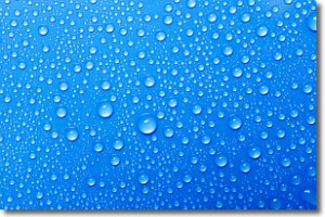
Weather Topic: What is Condensation?
Home - Education - Precipitation - Condensation
 Next Topic: Contrails
Condensation is the process which creates clouds, and therefore
it is a crucial process in the water cycle.
Condensation is the change of matter from a state of gas into a state of liquid,
and it happens because water molecules release heat into the atmosphere and
become organized into a more closely packed structure, what we might see as
water droplets.
Water is always present in the air around us as a vapor, but it's too small for
us to see. When water undergoes the process of condensation it becomes organized
into visible water droplets. You've probably seen condensation happen before on the
surface of a cold drink!
Next Topic: Contrails
Current conditions powered by WeatherAPI.com


