Weather Alert in Arizona
Dust Storm Warning issued August 31 at 3:38PM MST until August 31 at 5:15PM MST by NWS Tucson AZ
AREAS AFFECTED: Cochise, AZ
DESCRIPTION: The National Weather Service in Tucson has issued a * Dust Storm Warning for... Central Cochise County in southeastern Arizona... * Until 515 PM MST. * At 338 PM MST, an area of blowing dust was located 11 miles northeast of Pearce-Sunsites, moving southwest at 20 mph. HAZARD...Less than a quarter mile visibility with wind gusts up to 50 mph. SOURCE...Detected by National Weather Service meteorologists. IMPACT...Dangerous life-threatening travel. * Locations impacted include... Bisbee, Willcox, Tombstone, Dragoon, Pearce-Sunsites, Bisbee-Douglas Airport, Cochise, Elfrida, Sunizona, McNeal, Kansas Settlement and Texas Canyon. This includes the following highways... Route 90 between mile markers 333 and 336. Route 80 between mile markers 315 and 339...and between mile markers 375 and 384. Route 181 between mile markers 39 and 55. Route 191 between mile markers 7 and 66. Interstate 10 between mile markers 318 and 349. Route 186 between mile markers 327 and 352.
INSTRUCTION: Motorists should not drive into a dust storm. PULL ASIDE STAY ALIVE!
Want more detail? Get the Complete 7 Day and Night Detailed Forecast!
Current U.S. National Radar--Current
The Current National Weather Radar is shown below with a UTC Time (subtract 5 hours from UTC to get Eastern Time).

National Weather Forecast--Current
The Current National Weather Forecast and National Weather Map are shown below.

National Weather Forecast for Tomorrow
Tomorrow National Weather Forecast and Tomorrow National Weather Map are show below.

North America Water Vapor (Moisture)
This map shows recent moisture content over North America. Bright and colored areas show high moisture (ie, clouds); brown indicates very little moisture present; black indicates no moisture.

Weather Topic: What are Cumulonimbus Clouds?
Home - Education - Cloud Types - Cumulonimbus Clouds
 Next Topic: Cumulus Clouds
The final form taken by a growing cumulus cloud is the
cumulonimbus cloud, which is very tall and dense.
The tower of a cumulonimbus cloud can soar 23 km into the atmosphere, although
most commonly they stop growing at an altitude of 6 km.
Even small cumulonimbus clouds appear very large in comparison to other cloud types.
They can signal the approach of stormy weather, such as thunderstorms or blizzards.
Next Topic: Cumulus Clouds
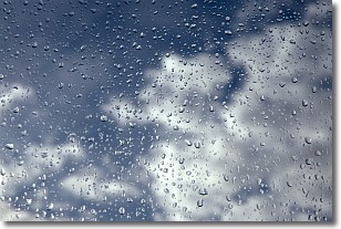
Weather Topic: What is Drizzle?
Home - Education - Precipitation - Drizzle
 Next Topic: Evaporation
Drizzle is precipitation in the form of water droplets which are
smaller than raindrops.
Drizzle is characterized by fine, gently falling droplets and typically does not
impact human habitation in a negative way. The exception to this is freezing drizzle,
a condition where drizzle freezes immediately upon reaching earth's surface.
Freezing drizzle is still less dangerous than freezing rain, but can
potentially result in hazardous road conditions.
Next Topic: Evaporation
Current conditions powered by WeatherAPI.com


