Weather Alert in Virginia
Severe Thunderstorm Warning issued August 25 at 1:01AM EDT until August 25 at 1:30AM EDT by NWS Baltimore MD/Washington DC
AREAS AFFECTED: Frederick, VA; Berkeley, WV; Hampshire, WV; Morgan, WV
DESCRIPTION: SVRLWX The National Weather Service in Sterling Virginia has issued a * Severe Thunderstorm Warning for... North central Frederick County in northwestern Virginia... Southwestern Morgan County in the Panhandle of West Virginia... West central Berkeley County in the Panhandle of West Virginia... East central Hampshire County in eastern West Virginia... * Until 130 AM EDT. * At 101 AM EDT, a severe thunderstorm was located 8 miles south of Paw Paw, moving east at 30 mph. HAZARD...60 mph wind gusts and quarter size hail. SOURCE...Radar indicated. IMPACT...Damaging winds will cause some trees and large branches to fall. This could injure those outdoors, as well as damage homes and vehicles. Roadways may become blocked by downed trees. Localized power outages are possible. Unsecured light objects may become projectiles. * Locations impacted include... Greenwood, Omps, Largent, Valley High, Unger, Oakland, Stotlers Crossroads, Bloomery, and Ridge.
INSTRUCTION: For your protection move to an interior room on the lowest floor of a building.
Want more detail? Get the Complete 7 Day and Night Detailed Forecast!
Current U.S. National Radar--Current
The Current National Weather Radar is shown below with a UTC Time (subtract 5 hours from UTC to get Eastern Time).

National Weather Forecast--Current
The Current National Weather Forecast and National Weather Map are shown below.

National Weather Forecast for Tomorrow
Tomorrow National Weather Forecast and Tomorrow National Weather Map are show below.

North America Water Vapor (Moisture)
This map shows recent moisture content over North America. Bright and colored areas show high moisture (ie, clouds); brown indicates very little moisture present; black indicates no moisture.

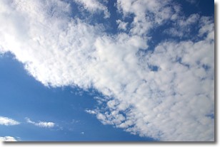
Weather Topic: What are Altocumulus Clouds?
Home - Education - Cloud Types - Altocumulus Clouds
 Next Topic: Altostratus Clouds
Similar to cirrocumulus clouds, altocumulus clouds are
characterized by cloud patches. They are distinguished by larger cloudlets
than cirrocumulus clouds but are still smaller than stratocumulus clouds.
Altocumulus clouds most commonly form in middle altitudes (between 2 and 5 km)
and may resemble, at times, the shape of a flying saucer.
These uncommon formations, called altocumulus lenticularis, are created by uplift
in the atmosphere and are most often seen in close proximity to mountains.
Next Topic: Altostratus Clouds
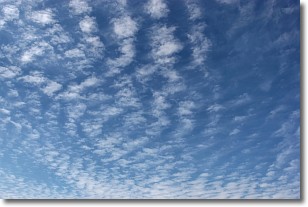
Weather Topic: What are Cirrocumulus Clouds?
Home - Education - Cloud Types - Cirrocumulus Clouds
 Next Topic: Cirrostratus Clouds
Cirrocumulus clouds form at high altitudes (usually around 5 km)
and have distinguishing characteristics displayed in a fine layer of
small cloud patches. These small cloud patches are sometimes referred to as
"cloudlets" in relation to the whole cloud formation.
Cirrocumulus clouds are formed from ice crystals and water droplets. Often, the
water droplets in the cloud freeze into ice crystals and the cloud becomes a
cirrostratus cloud. Because of this common occurrence, cirrocumulus cloud
formations generally pass rapidly.
Next Topic: Cirrostratus Clouds
Current conditions powered by WeatherAPI.com


