Weather Alert in Montana
Air Quality Alert issued September 2 at 9:03AM MDT by NWS Great Falls MT
AREAS AFFECTED: Daniels, MT; Dawson, MT; McCone, MT; Richland, MT; Roosevelt, MT; Sheridan, MT; Valley, MT
DESCRIPTION: AQAMT The Montana Department of Environmental Quality has issued an air quality alert for Daniels, Dawson, McCone, Richland, Roosevelt, Sheridan, Valley counties in effect until 9AM on 09/03/2025 An Air Quality Alert means that particulates have been trending upwards and that an exceedence of the 24 hour National Ambient Air Quality Standard (NAAQS) has occurred or may occur in the near future. Elevated particulate levels from wildfire smoke As of 8AM on 09/02/2025, particulate levels in Glendive are Unhealthy for Sensitive Groups. As of 8AM on 09/02/2025, particulate levels in Billings, Butte, Columbia Falls, Cut Bank, Frenchtown, Great Falls, Lewistown, Missoula, Seeley Lake, Sidney and Thompson Falls are Moderate. When air quality is Unhealthy for Sensitive Groups... State and local health officials recommend that people with respiratory or heart disease, the elderly and children should limit prolonged exertion. When air quality is Moderate... State and local health officials recommend that unusually sensitive people should consider reducing prolonged or heavy exertion. For more information visit the Montana Department of Environmental Quality at http://todaysair.mtdeq.us
INSTRUCTION: N/A
Want more detail? Get the Complete 7 Day and Night Detailed Forecast!
Current U.S. National Radar--Current
The Current National Weather Radar is shown below with a UTC Time (subtract 5 hours from UTC to get Eastern Time).

National Weather Forecast--Current
The Current National Weather Forecast and National Weather Map are shown below.

National Weather Forecast for Tomorrow
Tomorrow National Weather Forecast and Tomorrow National Weather Map are show below.

North America Water Vapor (Moisture)
This map shows recent moisture content over North America. Bright and colored areas show high moisture (ie, clouds); brown indicates very little moisture present; black indicates no moisture.

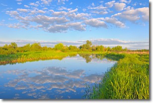
Weather Topic: What are Stratocumulus Clouds?
Home - Education - Cloud Types - Stratocumulus Clouds
 Next Topic: Stratus Clouds
Stratocumulus clouds are similar to altocumulus clouds in their
fluffy appearance, but have a slightly darker shade due to their additional mass.
A good way to distinguish the two cloud types is to hold your hand out and measure
the size of an individual cloud; if it is the size of your thumb it is generally
an altocumulus cloud, if it is the size of your hand it is generally a
stratocumulus cloud.
It is uncommon for stratocumulus clouds to produce precipitation, but if they do
it is usually a light rain or snow.
Next Topic: Stratus Clouds
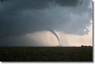
Weather Topic: What are Wall Clouds?
Home - Education - Cloud Types - Wall Clouds
 Next Topic: Altocumulus Clouds
A wall cloud forms underneath the base of a cumulonimbus cloud,
and can be a hotbed for deadly tornadoes.
Wall clouds are formed by air flowing into the cumulonimbus clouds, which can
result in the wall cloud descending from the base of the cumulonimbus cloud, or
rising fractus clouds which join to the base of the storm cloud as the wall cloud
takes shape.
Wall clouds can be very large, and in the Northern Hemisphere they generally
form at the southern edge of cumulonimbus clouds.
Next Topic: Altocumulus Clouds
Current conditions powered by WeatherAPI.com


