Weather Alert in Massachusetts
Coastal Flood Advisory issued August 21 at 1:03PM EDT until August 22 at 2:00AM EDT by NWS Boston/Norton MA
AREAS AFFECTED: Dukes; Nantucket
DESCRIPTION: * WHAT...Large breaking waves of 15 to 20 feet on south coastal beaches. Flooding of up to one foot deep on vulnerable coastal roads around high tide late tonight and late Friday night. * WHERE...Marthas Vineyard and Nantucket. * WHEN...For the High Surf Advisory, until 8 PM EDT Saturday. For the Coastal Flood Advisory, for high tides late tonight and late Friday night. * IMPACTS...Roads remain passable. Low lying areas and roads near Nantucket Harbor, including Easy Street, and Edgartown Harbor may experience pockets of shallow flooding less than one foot deep. Dangerous swimming and surfing conditions and significant beach and dune erosion.
INSTRUCTION: Do not drive around barricades or through water of unknown depth during high tide. Take the necessary actions to protect flood- prone property. Many ocean beaches are closed. Stay out out of the water due to dangerous surf conditions. Only view surf at a safe distance, not from near the shore.
Want more detail? Get the Complete 7 Day and Night Detailed Forecast!
Current U.S. National Radar--Current
The Current National Weather Radar is shown below with a UTC Time (subtract 5 hours from UTC to get Eastern Time).

National Weather Forecast--Current
The Current National Weather Forecast and National Weather Map are shown below.

National Weather Forecast for Tomorrow
Tomorrow National Weather Forecast and Tomorrow National Weather Map are show below.

North America Water Vapor (Moisture)
This map shows recent moisture content over North America. Bright and colored areas show high moisture (ie, clouds); brown indicates very little moisture present; black indicates no moisture.

Weather Topic: What are Cirrus Clouds?
Home - Education - Cloud Types - Cirrus Clouds
 Next Topic: Condensation
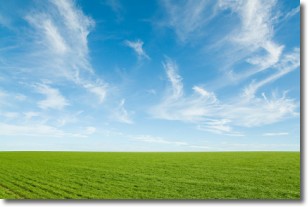
Cirrus clouds are high-level clouds that occur above 20,000 feet
and are composed mainly of ice crystals.
They are thin and wispy in appearance.
What do they indicate?
They are often the first sign of an approaching storm.
Next Topic: Condensation
Weather Topic: What are Contrails?
Home - Education - Cloud Types - Contrails
 Next Topic: Cumulonimbus Clouds
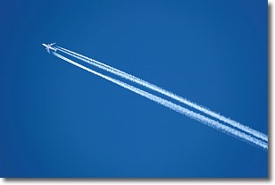
A contrail is an artificial cloud, created by the passing of an
aircraft.
Contrails form because water vapor in the exhaust of aircraft engines is suspended
in the air under certain temperatures and humidity conditions. These contrails
are called exhaust contrails.
Another type of contrail can form due to a temporary reduction in air pressure
moving over the plane's surface, causing condensation.
These are called aerodynamic contrails.
When you can see your breath on a cold day, it is also because of condensation.
The reason contrails last longer than the condensation from your breath is
because the water in contrails freezes into ice particles.
Next Topic: Cumulonimbus Clouds
Current conditions powered by WeatherAPI.com


