Weather Alert in Nevada
Hydrologic Outlook issued August 22 at 11:29PM PDT by NWS Elko NV
AREAS AFFECTED: Elko, NV; Eureka, NV
DESCRIPTION: ESFLKN Deep, monsoonal moisture will surge northward into most of Northern and Central Nevada Sunday afternoon through Wednesday evening. As a result, showers and thunderstorms will develop across much of Northern and Central Nevada each afternoon and evening Sunday through Wednesday. Slow storm motions may result in heavy rainfall and localized flooding. Of great concern will be recent, large burn scars left from the following incidents: the Snowstorm Complex near Midas, the Cottonwood Peak fire north of Tuscarora, the Hot Canyon fire northwest of Montello, and the Adobe fire north of Elko. Numerous other smaller burn scars have been created this past fire season and are also of concern. If living near recently burned areas, please have a way to receive flash flood warnings and be prepared to take action should warnings be issued. If you are traveling or recreating in areas that have burn scars, please consider changing plans.
INSTRUCTION: N/A
Want more detail? Get the Complete 7 Day and Night Detailed Forecast!
Current U.S. National Radar--Current
The Current National Weather Radar is shown below with a UTC Time (subtract 5 hours from UTC to get Eastern Time).

National Weather Forecast--Current
The Current National Weather Forecast and National Weather Map are shown below.

National Weather Forecast for Tomorrow
Tomorrow National Weather Forecast and Tomorrow National Weather Map are show below.

North America Water Vapor (Moisture)
This map shows recent moisture content over North America. Bright and colored areas show high moisture (ie, clouds); brown indicates very little moisture present; black indicates no moisture.

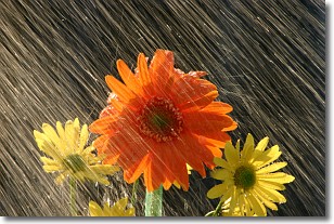
Weather Topic: What is Precipitation?
Home - Education - Precipitation - Precipitation
 Next Topic: Rain
Precipitation can refer to many different forms of water that
may fall from clouds. Precipitation occurs after a cloud has become saturated to
the point where its water particles are more dense than the air below the cloud.
In most cases, precipitation will reach the ground, but it is not uncommon for
precipitation to evaporate before it reaches the earth's surface.
When precipitation evaporates before it contacts the ground it is called Virga.
Graupel, hail, sleet, rain, drizzle, and snow are forms of precipitation, but fog
and mist are not considered precipitation because the water vapor which
constitutes them isn't dense enough to fall to the ground.
Next Topic: Rain
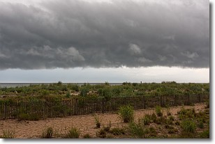
Weather Topic: What are Shelf Clouds?
Home - Education - Cloud Types - Shelf Clouds
 Next Topic: Sleet
A shelf cloud is similar to a wall cloud, but forms at the front
of a storm cloud, instead of at the rear, where wall clouds form.
A shelf cloud is caused by a series of events set into motion by the advancing
storm; first, cool air settles along the ground where precipitation has just fallen.
As the cool air is brought in, the warmer air is displaced, and rises above it,
because it is less dense. When the warmer air reaches the bottom of the storm cloud,
it begins to cool again, and the resulting condensation is a visible shelf cloud.
Next Topic: Sleet
Current conditions powered by WeatherAPI.com


