Weather Alert in Wisconsin
Ice Storm Warning issued April 2 at 2:54AM CDT until April 2 at 10:00AM CDT by NWS La Crosse WI
AREAS AFFECTED: Jackson
DESCRIPTION: ...FREEZING RAIN IMPACTS THE AREA THIS MORNING... .Freezing rain will develop overnight and persists into this morning. it will end from south to north through the morning hours. Greatest ice accumulations are forecast along and north of Interstate 94 with icing amounts of a quarter to nearly half an inch possible in a few locations. Closer to Interstate 90, impacts vary more in space and time with ridge tops and bridges possibly seeing more impacts versus the valleys and ground. * WHAT...Significant icing. Additional snow accumulations up to one inch and ice accumulations around two tenths of an inch. * WHERE...Jackson County. * WHEN...Until 10 AM CDT this morning. * IMPACTS...Plan on slippery road conditions. The hazardous conditions could impact the Thursday morning commute.
INSTRUCTION: Travel is strongly discouraged. If you must travel, keep an extra flashlight, food and water in your vehicle in case of an emergency. Prepare for possible power outages. Visit 511wi.gov for road conditions.
Want more detail? Get the Complete 7 Day and Night Detailed Forecast!
Current U.S. National Radar--Current
The Current National Weather Radar is shown below with a UTC Time (subtract 5 hours from UTC to get Eastern Time).

National Weather Forecast--Current
The Current National Weather Forecast and National Weather Map are shown below.

National Weather Forecast for Tomorrow
Tomorrow National Weather Forecast and Tomorrow National Weather Map are show below.

North America Water Vapor (Moisture)
This map shows recent moisture content over North America. Bright and colored areas show high moisture (ie, clouds); brown indicates very little moisture present; black indicates no moisture.

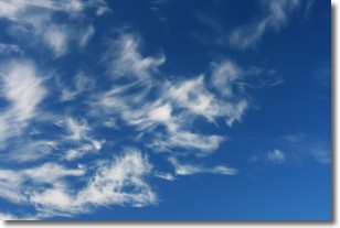
Weather Topic: What are Altostratus Clouds?
Home - Education - Cloud Types - Altostratus Clouds
 Next Topic: Cirrocumulus Clouds
Altostratus clouds form at mid to high-level altitudes
(between 2 and 7 km) and are created by a warm, stable air mass which causes
water vapor
to condense as it rise through the atmosphere. Usually altostratus clouds are
featureless sheets characterized by a uniform color.
In some cases, wind punching through the cloud formation may give it a waved
appearance, called altostratus undulatus. Altostratus clouds
are commonly seen with other cloud formations accompanying them.
Next Topic: Cirrocumulus Clouds
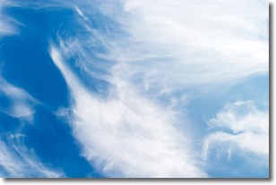
Weather Topic: What are Cirrostratus Clouds?
Home - Education - Cloud Types - Cirrostratus Clouds
 Next Topic: Cirrus Clouds
Cirrostratus clouds are high, thin clouds that form above
20,000 feet and are made mostly of ice crystals. They sometimes look like giant
feathers, horse tails, or curls of hair in the sky.
These clouds are pushed by the jet stream and can move at high speeds reaching
100 mph.
What do they indicate?
They indicate that a precipitation is likely within 24 hours.
Next Topic: Cirrus Clouds
Current conditions powered by WeatherAPI.com


