Weather Alert in New York
Special Weather Statement issued September 4 at 4:31AM EDT by NWS Albany NY
AREAS AFFECTED: Northern Saratoga; Northern Warren; Northern Washington; Western Schenectady; Eastern Schenectady; Southern Saratoga; Western Albany; Eastern Albany; Western Rensselaer; Eastern Rensselaer; Eastern Greene; Western Columbia; Eastern Columbia; Eastern Ulster; Western Dutchess; Eastern Dutchess; Southeast Warren; Southern Washington
DESCRIPTION: The combination of dry fuels, southerly winds gusting between 25 and 35 mph, and relative humidity values between 35 and 40 percent will contribute to an elevated risk for fire spread today. The risk of fire spread will be highest in the Upper Hudson Valley/Champlain and Hudson Valley Fire Danger Rating Areas. This includes Warren, Saratoga, Washington, Schenectady, Albany, Rensselaer, Columbia, Dutchess, eastern Greene and eastern Ulster Counties. Any fires that develop in these areas could spread rapidly and become difficult to contain. Residents are encouraged to exercise caution if handling any potential ignition sources, such as machinery, cigarettes, or matches. This product was issued in coordination the the New York State Department of Environmental Conservation. For more information about wildfire danger and wildfire prevention, please visit their website at http://dec.ny.gov/environmental-protection/wildfires.
INSTRUCTION: N/A
Want more detail? Get the Complete 7 Day and Night Detailed Forecast!
Current U.S. National Radar--Current
The Current National Weather Radar is shown below with a UTC Time (subtract 5 hours from UTC to get Eastern Time).

National Weather Forecast--Current
The Current National Weather Forecast and National Weather Map are shown below.

National Weather Forecast for Tomorrow
Tomorrow National Weather Forecast and Tomorrow National Weather Map are show below.

North America Water Vapor (Moisture)
This map shows recent moisture content over North America. Bright and colored areas show high moisture (ie, clouds); brown indicates very little moisture present; black indicates no moisture.

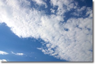
Weather Topic: What are Altocumulus Clouds?
Home - Education - Cloud Types - Altocumulus Clouds
 Next Topic: Altostratus Clouds
Similar to cirrocumulus clouds, altocumulus clouds are
characterized by cloud patches. They are distinguished by larger cloudlets
than cirrocumulus clouds but are still smaller than stratocumulus clouds.
Altocumulus clouds most commonly form in middle altitudes (between 2 and 5 km)
and may resemble, at times, the shape of a flying saucer.
These uncommon formations, called altocumulus lenticularis, are created by uplift
in the atmosphere and are most often seen in close proximity to mountains.
Next Topic: Altostratus Clouds
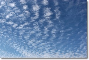
Weather Topic: What are Cirrocumulus Clouds?
Home - Education - Cloud Types - Cirrocumulus Clouds
 Next Topic: Cirrostratus Clouds
Cirrocumulus clouds form at high altitudes (usually around 5 km)
and have distinguishing characteristics displayed in a fine layer of
small cloud patches. These small cloud patches are sometimes referred to as
"cloudlets" in relation to the whole cloud formation.
Cirrocumulus clouds are formed from ice crystals and water droplets. Often, the
water droplets in the cloud freeze into ice crystals and the cloud becomes a
cirrostratus cloud. Because of this common occurrence, cirrocumulus cloud
formations generally pass rapidly.
Next Topic: Cirrostratus Clouds
Current conditions powered by WeatherAPI.com


