Weather Alert in Vermont
Special Weather Statement issued September 4 at 4:31AM EDT by NWS Albany NY
AREAS AFFECTED: Bennington; Western Windham; Eastern Windham
DESCRIPTION: Fine fuels remain very dry across the area according to the Vermont Department of Forests, Parks and Recreation. Southerly winds today will increase to 10 to 15 mph with gusts up to 25 mph across southern Vermont. This, combined with expected low relative humidity values between 35 and 40 percent will create near critical fire weather conditions this afternoon. Winds will be strongest between noon and 8 PM, coinciding with the timing of the minimum relative humidity values. If any fires were to start, the weather and fuel conditions could cause fires to quickly get out of control and be difficult to contain. Fire weather conditions will quickly improve with a wetting rainfall expected this evening into tonight. For more information about the current fire danger rating, any burn restrictions, and wildfire prevention and education, please visit your state forestry or environmental protection website.
INSTRUCTION: N/A
Want more detail? Get the Complete 7 Day and Night Detailed Forecast!
Current U.S. National Radar--Current
The Current National Weather Radar is shown below with a UTC Time (subtract 5 hours from UTC to get Eastern Time).

National Weather Forecast--Current
The Current National Weather Forecast and National Weather Map are shown below.

National Weather Forecast for Tomorrow
Tomorrow National Weather Forecast and Tomorrow National Weather Map are show below.

North America Water Vapor (Moisture)
This map shows recent moisture content over North America. Bright and colored areas show high moisture (ie, clouds); brown indicates very little moisture present; black indicates no moisture.

Weather Topic: What is Sleet?
Home - Education - Precipitation - Sleet
 Next Topic: Snow
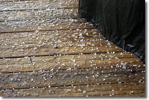
Sleet is a form of precipitation in which small ice pellets are the primary
components. These ice pellets are smaller and more translucent than hailstones,
and harder than graupel. Sleet is caused by specific atmospheric conditions and
therefore typically doesn't last for extended periods of time.
The condition which leads to sleet formation requires a warmer body of air to be
wedged in between two sub-freezing bodies of air. When snow falls through a warmer
layer of air it melts, and as it falls through the next sub-freezing body of air
it freezes again, forming ice pellets known as sleet. In some cases, water
droplets don't have time to freeze before reaching the surface and the result is
freezing rain.
Next Topic: Snow
Weather Topic: What are Stratocumulus Clouds?
Home - Education - Cloud Types - Stratocumulus Clouds
 Next Topic: Stratus Clouds
Stratocumulus clouds are similar to altocumulus clouds in their
fluffy appearance, but have a slightly darker shade due to their additional mass.
A good way to distinguish the two cloud types is to hold your hand out and measure
the size of an individual cloud; if it is the size of your thumb it is generally
an altocumulus cloud, if it is the size of your hand it is generally a
stratocumulus cloud.
It is uncommon for stratocumulus clouds to produce precipitation, but if they do
it is usually a light rain or snow.
Next Topic: Stratus Clouds
Current conditions powered by WeatherAPI.com


