Weather Alert in California
Dust Advisory issued August 25 at 3:10PM PDT until August 25 at 4:15PM PDT by NWS Phoenix AZ
AREAS AFFECTED: Imperial, CA
DESCRIPTION: The National Weather Service in Phoenix has issued a * Dust Advisory for... Southwestern Imperial County in southeastern California... * Until 415 PM PDT. * At 309 PM PDT, a wall of dust was along a line extending from near Calexico to near El Centro Naval Airfield to Plaster City. HAZARD...Less than one mile visibility with strong wind in excess of 50 mph. SOURCE...Doppler radar. IMPACT...Hazardous travel. * This includes the following highways... CA Interstate 8 near mile marker 1, and between mile markers 3 and 60. CA Route 111 between mile markers 1 and 19. CA Route 86 between mile markers 1 and 17. Locations impacted include... El Centro, Calexico, Imperial, Plaster City, Ocotillo, Holtville, Mt. Signal, El Centro Naval Airfield, Coyote Wells, Seeley, Bonds Corner, Heber, and Dixieland.
INSTRUCTION: Blowing dust brings reduced visibility, leading to dangerous driving conditions. If driving, avoid blowing dust if possible. If caught in dense blowing dust, pull off the road, turn off your lights and keep your foot off the brake. Motorists should not drive into an area of blowing dust. PULL ASIDE STAY ALIVE! Strong to severe thunderstorms are also possible behind this wall of dust. Keep updated with this quickly evolving situation.
Want more detail? Get the Complete 7 Day and Night Detailed Forecast!
Current U.S. National Radar--Current
The Current National Weather Radar is shown below with a UTC Time (subtract 5 hours from UTC to get Eastern Time).

National Weather Forecast--Current
The Current National Weather Forecast and National Weather Map are shown below.

National Weather Forecast for Tomorrow
Tomorrow National Weather Forecast and Tomorrow National Weather Map are show below.

North America Water Vapor (Moisture)
This map shows recent moisture content over North America. Bright and colored areas show high moisture (ie, clouds); brown indicates very little moisture present; black indicates no moisture.

Weather Topic: What are Fractus Clouds?
Home - Education - Cloud Types - Fractus Clouds
 Next Topic: Freezing Rain
A fractus cloud (scud) is a fragmented, tattered cloud which has
likely been sheared off of another cloud. They are accessory clouds, meaning they
develop from parent clouds, and are named in a way which describes the original
cloud which contained them.
Fractus clouds which have originated from cumulus clouds are referred to as
cumulus fractus, while fractus clouds which have originated from stratus clouds
are referred to as stratus fractus. Under certain conditions a fractus cloud might
merge with another cloud, or develop into a cumulus cloud, but usually a
fractus cloud seen by itself will dissipate rapidly.
They are often observed on the leading and trailing edges of storm clouds,
and are a display of wind activity.
Next Topic: Freezing Rain
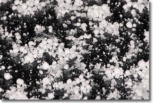
Weather Topic: What is Graupel?
Home - Education - Precipitation - Graupel
 Next Topic: Hail
Graupel is a form of precipitation that is created by atmospheric conditions
which cause supercooled water droplets to contact snow crystals and freeze to
their surface.
Sometimes known as soft hail or snow pellets, graupel is delicate and easily
destroyed by touch. Whereas hail usually falls during severe weather, graupel
doesn't require such conditions to form, and can form in mild precipitation
similar to situations which produce snowfall.
Next Topic: Hail
Current conditions powered by WeatherAPI.com


