Weather Alert in Texas
Flood Warning issued September 2 at 9:12AM CDT until September 2 at 10:16PM CDT by NWS Midland/Odessa TX
AREAS AFFECTED: Presidio, TX
DESCRIPTION: ...The National Weather Service in Midland/Odessa TX has issued a Flood Warning for the following rivers in Texas... Rio Grande at Rio Grande at Presidio Vehicle Bridge affecting Presidio County. * WHAT...Minor flooding is occurring. * WHERE...Rio Grande at Rio Grande at Presidio Vehicle Bridge. * WHEN...From this morning to late this evening. * IMPACTS...At 12.0 feet (3.7 meters), the river reaches bankfull, after which the flood plain between the levees begins to flood. No damage is expected. At 15.5 feet (4.7 meters), the river reaches minor flood stage, and flooding between the levees occurs. No damage to structures is expected. * ADDITIONAL DETAILS... - At 8:15 AM CDT Tuesday the stage was 16.5 feet (5.0 meters). - Bankfull stage is 12.0 feet (3.7 meters). - Recent Activity...The maximum river stage in the 24 hours ending at 8:15 AM CDT Tuesday was 18.2 feet (5.5 meters). - Forecast...The river is expected to fall below flood stage late this morning and continue falling to 6.2 feet (1.9 meters) Sunday morning. - Flood stage is 15.5 feet (4.7 meters). - Flood History...No available flood history. - http://www.weather.gov/safety/flood
INSTRUCTION: Please report observed flooding to local emergency services or law enforcement and request they pass this information to the National Weather Service when you can do so safely. Additional information is available at www.weather.gov. The next statement will be issued this evening at 915 PM CDT.
Want more detail? Get the Complete 7 Day and Night Detailed Forecast!
Current U.S. National Radar--Current
The Current National Weather Radar is shown below with a UTC Time (subtract 5 hours from UTC to get Eastern Time).

National Weather Forecast--Current
The Current National Weather Forecast and National Weather Map are shown below.

National Weather Forecast for Tomorrow
Tomorrow National Weather Forecast and Tomorrow National Weather Map are show below.

North America Water Vapor (Moisture)
This map shows recent moisture content over North America. Bright and colored areas show high moisture (ie, clouds); brown indicates very little moisture present; black indicates no moisture.

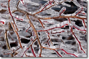
Weather Topic: What is Freezing Rain?
Home - Education - Precipitation - Freezing Rain
 Next Topic: Graupel
Freezing rain is a condition where precipitation which has fallen in the form of
water droplets reaches temperatures which are below freezing and freezes upon
coming into contact
with surface objects. The result of this precipitation is a glaze of ice which
can be damaging to plants and man-made structures. A severe onset of freezing
rain which results in a very thick glaze of ice is known as an ice storm.
Next Topic: Graupel
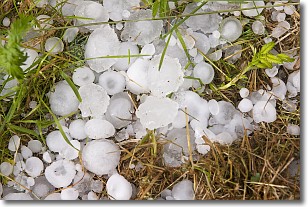
Weather Topic: What is Hail?
Home - Education - Precipitation - Hail
 Next Topic: Hole Punch Clouds
Hail is a form of precipitation which is recognized by large solid balls or
clumps of ice. Hail is created by thunderstorm clouds with strong updrafts of wind.
As the hailstones remain in the updraft, ice is deposited onto them until their
weight becomes heavy enough for them to fall to the earth's surface.
Hail storms can cause significant damage to crops, aircrafts, and man-made structures,
despite the fact that the duration is usually less than ten minutes.
Next Topic: Hole Punch Clouds
Current conditions powered by WeatherAPI.com


