Weather Alert in Alaska
Heat Advisory issued August 23 at 11:59AM AKDT until August 25 at 7:00PM AKDT by NWS Juneau AK
AREAS AFFECTED: City of Hyder
DESCRIPTION: * WHAT...High Temperatures exceeding 80 degrees expected. * WHERE...City of Hyder. * WHEN...Until 7 PM AKDT Monday. * IMPACTS...Individuals not accustomed to these unusually warm temperatures for this region may experience heat related illnesses. * ADDITIONAL DETAILS...Warm temperatures are expected each day through Monday, reaching well into the 80s for day time highs. Even though the heat advisory lasts into Monday evening, the warmest temperatures will be daily from noon into the early evening hours, with overnight temperatures then falling well into the 60s. Expect the warmest temperatures to be the farthest away from the water away from significant sea breeze influence.
INSTRUCTION: Drink plenty of fluids, check up on our elders, and especially check up on people you know who may be vulnerable to heat stress due to pre-existing health concerns. Young children and pets should never be left unattended in vehicles under any circumstances as vehicle interiors can reach extreme temperatures in as little as 10 minutes. Take extra precautions when working in the sun. Wear lightweight, loose fitting clothing. Try to limit strenuous activities to early morning or evening. Take action when you see symptoms of heat exhaustion and heat stroke. Close curtains during the daytime to reduce sun insolation into the home and open windows at night to allow the home to cool off. Utilize fans or community buildings with air conditioning.
Want more detail? Get the Complete 7 Day and Night Detailed Forecast!
Current U.S. National Radar--Current
The Current National Weather Radar is shown below with a UTC Time (subtract 5 hours from UTC to get Eastern Time).

National Weather Forecast--Current
The Current National Weather Forecast and National Weather Map are shown below.

National Weather Forecast for Tomorrow
Tomorrow National Weather Forecast and Tomorrow National Weather Map are show below.

North America Water Vapor (Moisture)
This map shows recent moisture content over North America. Bright and colored areas show high moisture (ie, clouds); brown indicates very little moisture present; black indicates no moisture.

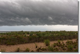
Weather Topic: What are Shelf Clouds?
Home - Education - Cloud Types - Shelf Clouds
 Next Topic: Sleet
A shelf cloud is similar to a wall cloud, but forms at the front
of a storm cloud, instead of at the rear, where wall clouds form.
A shelf cloud is caused by a series of events set into motion by the advancing
storm; first, cool air settles along the ground where precipitation has just fallen.
As the cool air is brought in, the warmer air is displaced, and rises above it,
because it is less dense. When the warmer air reaches the bottom of the storm cloud,
it begins to cool again, and the resulting condensation is a visible shelf cloud.
Next Topic: Sleet
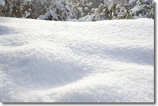
Weather Topic: What is Snow?
Home - Education - Precipitation - Snow
 Next Topic: Stratocumulus Clouds
Snow is precipitation taking the form of ice crystals. Each ice crystal, or snowflake,
has unique characteristics, but all of them grow in a hexagonal structure.
Snowfall can last for sustained periods of time and result in significant buildup
of snow on the ground.
On the earth's surface, snow starts out light and powdery, but as it begins to melt
it tends to become more granular, producing small bits of ice which have the consistency of
sand. After several cycles of melting and freezing, snow can become very dense
and ice-like, commonly known as snow pack.
Next Topic: Stratocumulus Clouds
Current conditions powered by WeatherAPI.com


