Weather Alert in New Mexico
Dust Storm Warning issued August 31 at 3:22PM MDT until August 31 at 4:00PM MDT by NWS El Paso Tx/Santa Teresa NM
AREAS AFFECTED: Hidalgo, NM
DESCRIPTION: The National Weather Service in El Paso has issued a * Dust Storm Warning for... West central Hidalgo County in southwestern New Mexico... * Until 400 PM MDT. * At 321 PM MDT, a dust channel was over Lordsburg, moving south at 20 mph. HAZARD...Less than a quarter mile visibility with strong wind in excess of 50 mph. SOURCE...Doppler radar. IMPACT...Dangerous life-threatening travel. * This includes Interstate 10 in New Mexico between mile markers 1 and 33. Locations impacted include... Lordsburg, Cotton City, Steins, Road Forks, Lordsburg Playa, Granite Gap, Pyramid Mountains, and Shakespeare.
INSTRUCTION: Dust storms lead to dangerous driving conditions with visibility reduced to near zero. If driving, avoid dust storms if possible. If caught in one, pull off the road, turn off your lights and keep your foot off the brake. Motorists should not drive into a dust storm. PULL ASIDE STAY ALIVE!
Want more detail? Get the Complete 7 Day and Night Detailed Forecast!
Current U.S. National Radar--Current
The Current National Weather Radar is shown below with a UTC Time (subtract 5 hours from UTC to get Eastern Time).

National Weather Forecast--Current
The Current National Weather Forecast and National Weather Map are shown below.

National Weather Forecast for Tomorrow
Tomorrow National Weather Forecast and Tomorrow National Weather Map are show below.

North America Water Vapor (Moisture)
This map shows recent moisture content over North America. Bright and colored areas show high moisture (ie, clouds); brown indicates very little moisture present; black indicates no moisture.

Weather Topic: What is Hail?
Home - Education - Precipitation - Hail
 Next Topic: Hole Punch Clouds
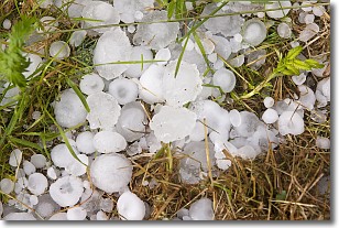
Hail is a form of precipitation which is recognized by large solid balls or
clumps of ice. Hail is created by thunderstorm clouds with strong updrafts of wind.
As the hailstones remain in the updraft, ice is deposited onto them until their
weight becomes heavy enough for them to fall to the earth's surface.
Hail storms can cause significant damage to crops, aircrafts, and man-made structures,
despite the fact that the duration is usually less than ten minutes.
Next Topic: Hole Punch Clouds
Weather Topic: What are Mammatus Clouds?
Home - Education - Cloud Types - Mammatus Clouds
 Next Topic: Nimbostratus Clouds
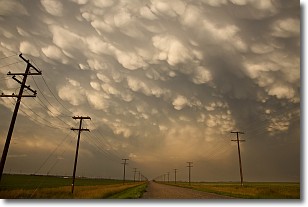
A mammatus cloud is a cloud with a unique feature which resembles
a web of pouches hanging along the base of the cloud.
In the United States, mammatus clouds tend to form in the warmer months, commonly
in the Midwest and eastern regions.
While they usually form at the bottom of a cumulonimbis cloud, they can also form
under altostratus, altocumulus, stratocumulus, and cirrus clouds. Mammatus clouds
warn that severe weather is close.
Next Topic: Nimbostratus Clouds
Current conditions powered by WeatherAPI.com


