Weather Alert in Iowa
Flood Watch issued August 22 at 8:21PM CDT until August 27 at 12:00PM CDT by NWS Quad Cities IA IL
AREAS AFFECTED: Muscatine; Louisa
DESCRIPTION: ...The National Weather Service in Quad Cities IA IL has issued a Flood Watch for the following rivers in Iowa... Cedar River near Conesville affecting Louisa and Muscatine Counties. .Heavy rainfall on the upper portions of the Cedar River basin during the past week may produce flooding on some sections of the Cedar River. * WHAT...Flooding is possible. * WHERE...Cedar River near Conesville. * WHEN...From late Sunday night to early Wednesday afternoon. * IMPACTS...At 13.5 feet, Water affects yards and access roads of residences along Iowa Highway 22. Water affects the lowest sections of campgrounds just north of I-80 along the river and the lowest sections of Jack Shuger Memorial Park in Moscow. Water is also on 152nd Street north of County Road F70. * ADDITIONAL DETAILS... - At 8:00 PM CDT Friday the stage was 11.0 feet and rising. - Forecast...Flood stage may be reached early Monday morning. - Flood stage is 13.0 feet.
INSTRUCTION: If you are in the watch area, remain alert to possible flooding. Stay tuned to further developments by listening to your local radio, television, or NOAA Weather Radio for further information. The next statement will be issued by Saturday evening at 830 PM CDT.
Want more detail? Get the Complete 7 Day and Night Detailed Forecast!
Current U.S. National Radar--Current
The Current National Weather Radar is shown below with a UTC Time (subtract 5 hours from UTC to get Eastern Time).

National Weather Forecast--Current
The Current National Weather Forecast and National Weather Map are shown below.

National Weather Forecast for Tomorrow
Tomorrow National Weather Forecast and Tomorrow National Weather Map are show below.

North America Water Vapor (Moisture)
This map shows recent moisture content over North America. Bright and colored areas show high moisture (ie, clouds); brown indicates very little moisture present; black indicates no moisture.

Weather Topic: What is Drizzle?
Home - Education - Precipitation - Drizzle
 Next Topic: Evaporation
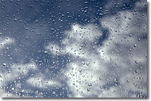
Drizzle is precipitation in the form of water droplets which are
smaller than raindrops.
Drizzle is characterized by fine, gently falling droplets and typically does not
impact human habitation in a negative way. The exception to this is freezing drizzle,
a condition where drizzle freezes immediately upon reaching earth's surface.
Freezing drizzle is still less dangerous than freezing rain, but can
potentially result in hazardous road conditions.
Next Topic: Evaporation
Weather Topic: What is Fog?
Home - Education - Cloud Types - Fog
 Next Topic: Fractus Clouds
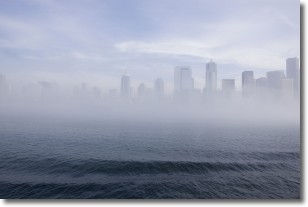
Fog is technically a type of stratus cloud, which lies along the
ground and obscures visibility.
It is usually created when humidity in the air condenses into tiny water droplets.
Because of this, some places are more prone to foggy weather, such as regions
close to a body of water.
Fog is similar to mist; both are the appearance of water droplets suspended in
the air, but fog is the term applied to the condition when visibility is less than 1 km.
Next Topic: Fractus Clouds
Current conditions powered by WeatherAPI.com


