Weather Alert in Kansas
Flood Warning issued August 27 at 1:58PM CDT until August 31 at 3:09AM CDT by NWS Wichita KS
AREAS AFFECTED: Harvey, KS
DESCRIPTION: ...The National Weather Service in Wichita KS has issued a Flood Warning for the following rivers in Kansas... Little Arkansas River At Alta Mills affecting Reno and Harvey Counties. Little Arkansas River Near Halstead affecting Harvey County. * WHAT...Minor flooding is forecast. This approaches the flood of record. * WHERE...Little Arkansas River near Halstead. * WHEN...From Friday afternoon to early Sunday morning. * IMPACTS...At 26.0 feet, Riverside Park floods north of the river. Flood waters may begin to encroach on K89 just north of the river bridge along with a trailer park and a few residences north of Halstead. Expect field flooding on both sides of Halstead Road north of the flood gates. More field flooding occurs north of Highway 50 on the east bank of the river. Just southeast of the city, SW 48th St becomes impassable from Hertzler Rd to Essex Heights. * ADDITIONAL DETAILS... - At 12:30 PM CDT Wednesday the stage was 6.0 feet. - Forecast...The river is expected to rise above flood stage early Friday afternoon to a crest of 26.2 feet early Saturday morning. It will then fall below flood stage Saturday afternoon. - Flood stage is 25.0 feet.
INSTRUCTION: Do not drive into flooded areas or go around barricades. Nearly two feet of water will carry most vehicles away. Turn around, don't drown. Additional information is available at www.weather.gov. The next statement will be issued late tonight at 200 AM CDT.
Want more detail? Get the Complete 7 Day and Night Detailed Forecast!
Current U.S. National Radar--Current
The Current National Weather Radar is shown below with a UTC Time (subtract 5 hours from UTC to get Eastern Time).

National Weather Forecast--Current
The Current National Weather Forecast and National Weather Map are shown below.

National Weather Forecast for Tomorrow
Tomorrow National Weather Forecast and Tomorrow National Weather Map are show below.

North America Water Vapor (Moisture)
This map shows recent moisture content over North America. Bright and colored areas show high moisture (ie, clouds); brown indicates very little moisture present; black indicates no moisture.

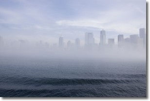
Weather Topic: What is Fog?
Home - Education - Cloud Types - Fog
 Next Topic: Fractus Clouds
Fog is technically a type of stratus cloud, which lies along the
ground and obscures visibility.
It is usually created when humidity in the air condenses into tiny water droplets.
Because of this, some places are more prone to foggy weather, such as regions
close to a body of water.
Fog is similar to mist; both are the appearance of water droplets suspended in
the air, but fog is the term applied to the condition when visibility is less than 1 km.
Next Topic: Fractus Clouds
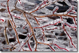
Weather Topic: What is Freezing Rain?
Home - Education - Precipitation - Freezing Rain
 Next Topic: Graupel
Freezing rain is a condition where precipitation which has fallen in the form of
water droplets reaches temperatures which are below freezing and freezes upon
coming into contact
with surface objects. The result of this precipitation is a glaze of ice which
can be damaging to plants and man-made structures. A severe onset of freezing
rain which results in a very thick glaze of ice is known as an ice storm.
Next Topic: Graupel
Current conditions powered by WeatherAPI.com


