Weather Alert in Iowa
Tornado Watch issued April 2 at 1:44PM CDT until April 2 at 8:00PM CDT by NWS Quad Cities IA IL
AREAS AFFECTED: Benton, IA; Buchanan, IA; Cedar, IA; Clinton, IA; Delaware, IA; Des Moines, IA; Dubuque, IA; Henry, IA; Iowa, IA; Jackson, IA; Jefferson, IA; Johnson, IA; Jones, IA; Keokuk, IA; Lee, IA; Linn, IA; Louisa, IA; Muscatine, IA; Scott, IA; Van Buren, IA; Washington, IA; Bureau, IL; Carroll, IL; Hancock, IL; Henderson, IL; Henry, IL; Jo Daviess, IL; McDonough, IL; Mercer, IL; Putnam, IL; Rock Island, IL; Stephenson, IL; Warren, IL; Whiteside, IL; Clark, MO; Scotland, MO
DESCRIPTION: THE NATIONAL WEATHER SERVICE HAS ISSUED TORNADO WATCH 89 IN EFFECT UNTIL 8 PM CDT THIS EVENING FOR THE FOLLOWING AREAS IN ILLINOIS THIS WATCH INCLUDES 13 COUNTIES IN NORTH CENTRAL ILLINOIS BUREAU PUTNAM IN NORTHWEST ILLINOIS CARROLL HENRY IL JO DAVIESS MERCER ROCK ISLAND STEPHENSON WHITESIDE IN WEST CENTRAL ILLINOIS HANCOCK HENDERSON MCDONOUGH WARREN IN IOWA THIS WATCH INCLUDES 21 COUNTIES IN EAST CENTRAL IOWA BENTON CEDAR CLINTON IOWA JACKSON JOHNSON JONES LINN MUSCATINE SCOTT IN NORTHEAST IOWA BUCHANAN DELAWARE DUBUQUE IN SOUTHEAST IOWA DES MOINES HENRY IA JEFFERSON KEOKUK LEE LOUISA VAN BUREN WASHINGTON IN MISSOURI THIS WATCH INCLUDES 2 COUNTIES IN NORTHEAST MISSOURI CLARK SCOTLAND THIS INCLUDES THE CITIES OF ALEDO, ANAMOSA, BETTENDORF, BURLINGTON, CARTHAGE, CEDAR RAPIDS, CLINTON, CREDIT ISLAND, DAVENPORT, DUBUQUE, FAIRFIELD, FREEPORT, GALENA, GENESEO, HENNEPIN, INDEPENDENCE, IOWA CITY, KAHOKA, KEOKUK, KEOSAUQUA, MACOMB, MANCHESTER, MAQUOKETA, MARENGO, MEMPHIS, MOLINE, MONMOUTH, MOUNT CARROLL, MOUNT PLEASANT, MUSCATINE, OQUAWKA, PRINCETON, ROCK ISLAND, SIGOURNEY, STERLING, TIPTON, VINTON, WAPELLO, AND WASHINGTON.
INSTRUCTION: N/A
Want more detail? Get the Complete 7 Day and Night Detailed Forecast!
Current U.S. National Radar--Current
The Current National Weather Radar is shown below with a UTC Time (subtract 5 hours from UTC to get Eastern Time).

National Weather Forecast--Current
The Current National Weather Forecast and National Weather Map are shown below.

National Weather Forecast for Tomorrow
Tomorrow National Weather Forecast and Tomorrow National Weather Map are show below.

North America Water Vapor (Moisture)
This map shows recent moisture content over North America. Bright and colored areas show high moisture (ie, clouds); brown indicates very little moisture present; black indicates no moisture.

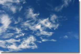
Weather Topic: What are Altostratus Clouds?
Home - Education - Cloud Types - Altostratus Clouds
 Next Topic: Cirrocumulus Clouds
Altostratus clouds form at mid to high-level altitudes
(between 2 and 7 km) and are created by a warm, stable air mass which causes
water vapor
to condense as it rise through the atmosphere. Usually altostratus clouds are
featureless sheets characterized by a uniform color.
In some cases, wind punching through the cloud formation may give it a waved
appearance, called altostratus undulatus. Altostratus clouds
are commonly seen with other cloud formations accompanying them.
Next Topic: Cirrocumulus Clouds
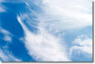
Weather Topic: What are Cirrostratus Clouds?
Home - Education - Cloud Types - Cirrostratus Clouds
 Next Topic: Cirrus Clouds
Cirrostratus clouds are high, thin clouds that form above
20,000 feet and are made mostly of ice crystals. They sometimes look like giant
feathers, horse tails, or curls of hair in the sky.
These clouds are pushed by the jet stream and can move at high speeds reaching
100 mph.
What do they indicate?
They indicate that a precipitation is likely within 24 hours.
Next Topic: Cirrus Clouds
Current conditions powered by WeatherAPI.com


