Weather Alert in Iowa
Tornado Watch issued April 2 at 1:44PM CDT until April 2 at 8:00PM CDT by NWS Quad Cities IA IL
AREAS AFFECTED: Benton, IA; Buchanan, IA; Cedar, IA; Clinton, IA; Delaware, IA; Des Moines, IA; Dubuque, IA; Henry, IA; Iowa, IA; Jackson, IA; Jefferson, IA; Johnson, IA; Jones, IA; Keokuk, IA; Lee, IA; Linn, IA; Louisa, IA; Muscatine, IA; Scott, IA; Van Buren, IA; Washington, IA; Bureau, IL; Carroll, IL; Hancock, IL; Henderson, IL; Henry, IL; Jo Daviess, IL; McDonough, IL; Mercer, IL; Putnam, IL; Rock Island, IL; Stephenson, IL; Warren, IL; Whiteside, IL; Clark, MO; Scotland, MO
DESCRIPTION: THE NATIONAL WEATHER SERVICE HAS ISSUED TORNADO WATCH 89 IN EFFECT UNTIL 8 PM CDT THIS EVENING FOR THE FOLLOWING AREAS IN ILLINOIS THIS WATCH INCLUDES 13 COUNTIES IN NORTH CENTRAL ILLINOIS BUREAU PUTNAM IN NORTHWEST ILLINOIS CARROLL HENRY IL JO DAVIESS MERCER ROCK ISLAND STEPHENSON WHITESIDE IN WEST CENTRAL ILLINOIS HANCOCK HENDERSON MCDONOUGH WARREN IN IOWA THIS WATCH INCLUDES 21 COUNTIES IN EAST CENTRAL IOWA BENTON CEDAR CLINTON IOWA JACKSON JOHNSON JONES LINN MUSCATINE SCOTT IN NORTHEAST IOWA BUCHANAN DELAWARE DUBUQUE IN SOUTHEAST IOWA DES MOINES HENRY IA JEFFERSON KEOKUK LEE LOUISA VAN BUREN WASHINGTON IN MISSOURI THIS WATCH INCLUDES 2 COUNTIES IN NORTHEAST MISSOURI CLARK SCOTLAND THIS INCLUDES THE CITIES OF ALEDO, ANAMOSA, BETTENDORF, BURLINGTON, CARTHAGE, CEDAR RAPIDS, CLINTON, CREDIT ISLAND, DAVENPORT, DUBUQUE, FAIRFIELD, FREEPORT, GALENA, GENESEO, HENNEPIN, INDEPENDENCE, IOWA CITY, KAHOKA, KEOKUK, KEOSAUQUA, MACOMB, MANCHESTER, MAQUOKETA, MARENGO, MEMPHIS, MOLINE, MONMOUTH, MOUNT CARROLL, MOUNT PLEASANT, MUSCATINE, OQUAWKA, PRINCETON, ROCK ISLAND, SIGOURNEY, STERLING, TIPTON, VINTON, WAPELLO, AND WASHINGTON.
INSTRUCTION: N/A
Want more detail? Get the Complete 7 Day and Night Detailed Forecast!
Current U.S. National Radar--Current
The Current National Weather Radar is shown below with a UTC Time (subtract 5 hours from UTC to get Eastern Time).

National Weather Forecast--Current
The Current National Weather Forecast and National Weather Map are shown below.

National Weather Forecast for Tomorrow
Tomorrow National Weather Forecast and Tomorrow National Weather Map are show below.

North America Water Vapor (Moisture)
This map shows recent moisture content over North America. Bright and colored areas show high moisture (ie, clouds); brown indicates very little moisture present; black indicates no moisture.

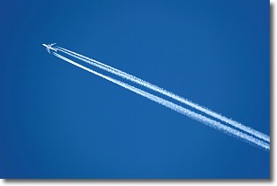
Weather Topic: What are Contrails?
Home - Education - Cloud Types - Contrails
 Next Topic: Cumulonimbus Clouds
A contrail is an artificial cloud, created by the passing of an
aircraft.
Contrails form because water vapor in the exhaust of aircraft engines is suspended
in the air under certain temperatures and humidity conditions. These contrails
are called exhaust contrails.
Another type of contrail can form due to a temporary reduction in air pressure
moving over the plane's surface, causing condensation.
These are called aerodynamic contrails.
When you can see your breath on a cold day, it is also because of condensation.
The reason contrails last longer than the condensation from your breath is
because the water in contrails freezes into ice particles.
Next Topic: Cumulonimbus Clouds
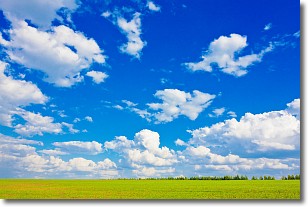
Weather Topic: What are Cumulus Clouds?
Home - Education - Cloud Types - Cumulus Clouds
 Next Topic: Drizzle
Cumulus clouds are fluffy and textured with rounded tops, and
may have flat bottoms. The border of a cumulus cloud
is clearly defined, and can have the appearance of cotton or cauliflower.
Cumulus clouds form at low altitudes (rarely above 2 km) but can grow very tall,
becoming cumulus congestus and possibly the even taller cumulonimbus clouds.
When cumulus clouds become taller, they have a greater chance of producing precipitation.
Next Topic: Drizzle
Current conditions powered by WeatherAPI.com


