Weather Alert in Michigan
Special Weather Statement issued August 23 at 7:47PM EDT by NWS Detroit/Pontiac MI
AREAS AFFECTED: Livingston; Oakland; Macomb; Washtenaw; Wayne
DESCRIPTION: At 747 PM EDT, Doppler radar was tracking strong thunderstorms along a line extending from West Bloomfield to near Salem to near Dexter. Movement was east at 40 mph. HAZARD...Winds in excess of 40 mph. SOURCE...Radar indicated. IMPACT...Gusty winds could knock down tree limbs and blow around unsecured objects. Strong thunderstorms will be near... Ann Arbor, Livonia, Southfield, Novi, Canton, Birmingham, Northville, and Dixboro around 750 PM EDT. Troy, Ypsilanti, and Royal Oak around 755 PM EDT. Dearborn and Detroit Zoo around 800 PM EDT. Warren, Romulus, Sterling Heights, and Greenfield Village around 805 PM EDT. Taylor, Detroit, and Belleville around 810 PM EDT. St. Clair Shores, Downtown Detroit, Wyandotte, and Belle Isle around 820 PM EDT. Grosse Pointe around 825 PM EDT. Trenton around 835 PM EDT. Other locations impacted by these storms include Franklin, Keego Harbor, Melvindale, Harper Woods, Westland, Pleasant Ridge, Grosse Pointe Shores, Huntington Woods, Wolverine Lake, and Woodhaven. People attending Clawson Fest , Novi Taco Fest and Art , Freedom Hill Amphitheatre , and Comerica Park should seek safe shelter immediately!
INSTRUCTION: If outdoors, consider seeking shelter inside a building.
Want more detail? Get the Complete 7 Day and Night Detailed Forecast!
Current U.S. National Radar--Current
The Current National Weather Radar is shown below with a UTC Time (subtract 5 hours from UTC to get Eastern Time).

National Weather Forecast--Current
The Current National Weather Forecast and National Weather Map are shown below.

National Weather Forecast for Tomorrow
Tomorrow National Weather Forecast and Tomorrow National Weather Map are show below.

North America Water Vapor (Moisture)
This map shows recent moisture content over North America. Bright and colored areas show high moisture (ie, clouds); brown indicates very little moisture present; black indicates no moisture.

Weather Topic: What are Fractus Clouds?
Home - Education - Cloud Types - Fractus Clouds
 Next Topic: Freezing Rain
A fractus cloud (scud) is a fragmented, tattered cloud which has
likely been sheared off of another cloud. They are accessory clouds, meaning they
develop from parent clouds, and are named in a way which describes the original
cloud which contained them.
Fractus clouds which have originated from cumulus clouds are referred to as
cumulus fractus, while fractus clouds which have originated from stratus clouds
are referred to as stratus fractus. Under certain conditions a fractus cloud might
merge with another cloud, or develop into a cumulus cloud, but usually a
fractus cloud seen by itself will dissipate rapidly.
They are often observed on the leading and trailing edges of storm clouds,
and are a display of wind activity.
Next Topic: Freezing Rain
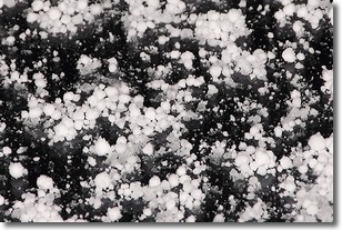
Weather Topic: What is Graupel?
Home - Education - Precipitation - Graupel
 Next Topic: Hail
Graupel is a form of precipitation that is created by atmospheric conditions
which cause supercooled water droplets to contact snow crystals and freeze to
their surface.
Sometimes known as soft hail or snow pellets, graupel is delicate and easily
destroyed by touch. Whereas hail usually falls during severe weather, graupel
doesn't require such conditions to form, and can form in mild precipitation
similar to situations which produce snowfall.
Next Topic: Hail
Current conditions powered by WeatherAPI.com


